
← Back to Class 9 Social Science Notes
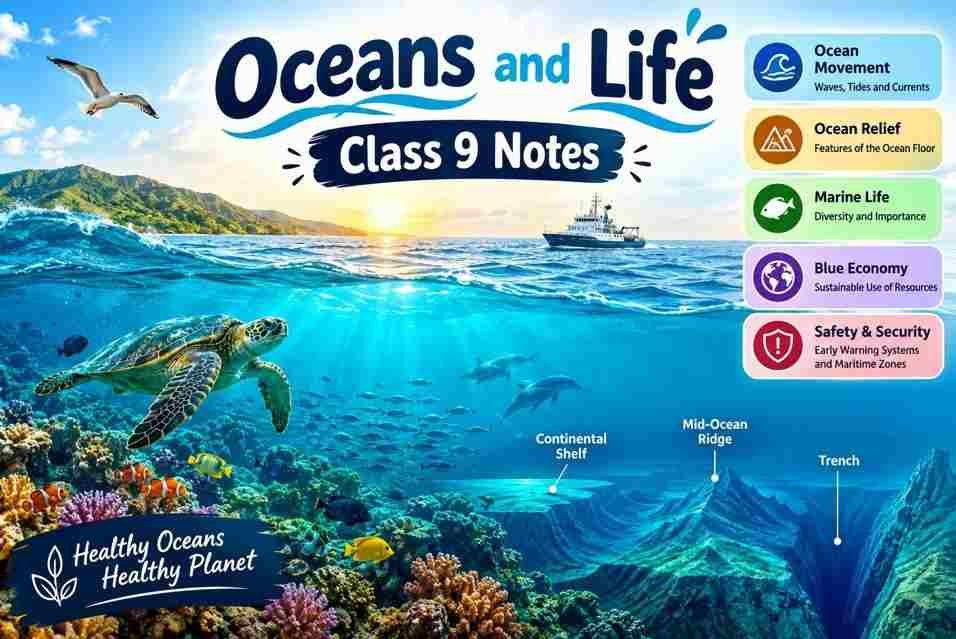
Oceans and Life Class 9 Notes help students understand the importance of oceans and their role in supporting life on Earth. These notes cover ocean features, waves, tides, ocean currents, marine resources, and the relationship between oceans and living beings. Students can use these easy-to-understand notes for revision and exam preparation.
Oceans and Life Class 9 Notes
The oceans cover most of the Earth’s surface. There are many things that are hidden under the sea, and the scientist is trying to search for them. The Indian Ocean is also called Samudra. The name Samudra is mentioned in many Indian stories and traditions. Some of the important points of the ocean are
- Ocean water is always in motion. Waves, tides, and currents shape our climate, support marine life, and impact travel.
- The gravitational pull creates tides. The daily rise and fall of sea level is crucial for navigation and generating tidal energy.
- The ocean floor is a hidden landscape. Like land, it has features like mountains, plains, mid-oceanic ridges, trenches, etc.
- The ‘Blue Economy’: sustaining ocean resources. Oceans provide food, energy, and jobs, which must be used sustainably.
- Early warning systems protect coastal life. Seismic sensors and satellites detect tsunamis and cyclones, allowing for timely evacuations.
- Maritime zones create ‘rules of the sea’. International laws like UNCLOS define a country’s rights from its coast to the high seas.
Ocean Relief
The ocean floor has different shapes; this ocean floor is called ocean relief. The ocean floor includes mountains, valleys, flatlands, and deep holes. The Mariana Trench is the deepest part of the ocean basin. The Mid-Ocean Ridge is a very long mountain range under the ocean. Some of the mountains inside the ocean are taller than Mount Everest.
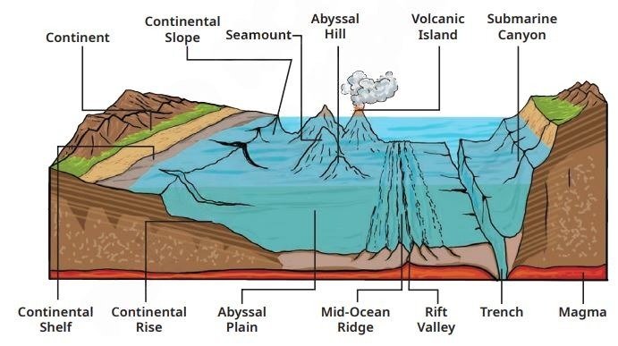
Important submarine relief features—
- Continental Shelf: Continental shelves are the shallow parts of the ocean near the land. In this area many fish and other sea animals live. Oil and gas are also found here.
- Continental Slope: It is the steep part of the ocean floor after the continental shelf. It goes down towards the deep ocean floor.
- Abyssal Plain: The Abyssal Plain is a very large, flat area under the deep ocean.
- Mid-Ocean Ridge: Inside the ocean, it is a long chain of mountains. These mountains are formed by volcanic activity.
- Ocean trenches: These are very deep and narrow parts of the ocean floor. The Mariana Trech is one example.
- Seamounts: These are mountains under the ocean. Many are formed by volcanoes.
- Guyots: These are the underwater mountains with flat tops. Their tops became flat due to the action of waves over a very long time.
Movement of Ocean Water—Waves, Tides, and Currents
The ocean water is always moving. The three main movements of the ocean water are waves, tides, and currents. This movement helps the sea animals to live. It also helps in fishing and sea travel and also affects the weather.
1. Waves
Waves are the up-and-down movements of water on the ocean’s surface. They are mainly due to wind blowing over the water.
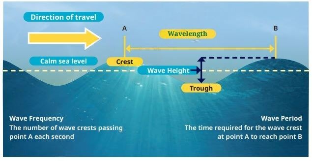
The top part of the wave is called the crest, and the lower parts are called the trough.
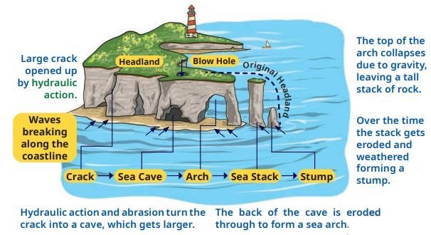
Waves can change the shape of the seashore. They can break rocks into small pieces and carry sand from one place to another. Waves from different land features are
- Sea cracks: Cracks in rocks near the sea.
- Sea caves: Holes formed in rocks by waves.
- Sea arches: Openings formed in rocks near the sea.
- Sea stacks: Tall rocks standing in the sea.
- Stumps: Short rocks left after sea stacks break down.
- Beaches: Places along the sea covered with sand or small stones.
Strong winds can create big waves. The tsunamis are the very big sea waves usually caused by earthquakes under the sea.
2. Tides
Tides are the regular rise and fall of ocean water. In most of the places, the tides happen twice in a day. There are two main types of tides.
- High Tide: When the seawater rises and covers more of the shore (ocean land), it is called high tide.
- Low Tide: When the seawater falls and moves away from the shore, it is called low tide.
The moon’s and sun’s gravitational force affect the ocean tides. Tides are important for fishing, boats, and sea travel. The tides are also used to produce electricity.
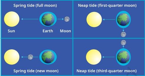
Spring Tides and Neap Tides
Spring Tides: The spring tides occur when the Sun, Moon, and Earth are in a straight line. This happens on full moon and new moon days. This time the sun and moon pull the ocean water together. So, the high tides become higher and the low tides become lower.
Neep Tides: The neep tides occur when the sun and moon pull the ocean water in different directions. This happens during the first-quarter and third-quarter moon phases. At this time the high tide and low tide become smaller.
Uses and Importance of Tides
- Helps Ships Travel: When the high tides are there, the water rises near the shore. This helps the ships to enter in the ocean.
- Help Ships Pass Through Shallow Areas: Some of the sea areas have shallow water. The large ships may wait for high tide so they can pass safely without touching the sea floor.
- Help Fishing: During the tide, many fish come closer to the shore to find food.
- Produce Electricity: The rise and fall of ocean water can be used to produce electricity. This is called tidal energy. The Gulf of Kutch, the Gulf of Khambhat, and the Sundarbans are among the major tidal energy sites in India.
3. Ocean Currents
Ocean currents are like a river of water flowing in the ocean. They move in fixed directions. Ocean currents are caused by Earth rotation, winds, differences in water temperature and salt and the shape of the ocean floor and earth land. There are two main types of ocean currents –
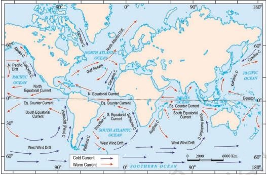
- Warm Currents: Warm currents carry warm water from warm areas to cold areas. The Gulf Stream is a warm ocean current. It carries warm water from the Gulf of Mexico towards Europe. It helps to make the warm water near Norway.
- Cold Currents: Cold currents carry cold water from cold areas to warm areas. The Labrador Current is a cold ocean current. It flows along the east coast of Canada. It brings cold water and helps icebergs and sea ice form in the region.
Important Points
- Ocean currents move water from one place to another.
- Warm currents carry warm water.
- Cold currents carry cold water.
- Ocean currents affect the temperature of nearby places.
- On maps, warm currents are usually shown in red, and cold currents are shown in blue.
Cyclones and Tsunamis—Early Warning Systems
The cyclones are large storms with strong winds that move around a centre. Tsunamis are very large sea waves usually caused by earthquakes under the sea. Both the cyclones and tsunamis can be dangerous for people living near the sea.
The early warning system warns the people about the possible danger before it happens. It helps the people to move to the safe places and protects lives. The early warning system helps us to use it.
- Detect cyclones and tsunamis.
- Give warnings to people on time.
- Help people move to safe places.
- Reduce damage to people, animals, and property.
Cyclone Warning Systems in India
India has special machines and technology to watch storms near its eastern and western coasts. These services help the scientists to predict cyclones early. The early warning helps the people to move to the safe places.
National Cyclone Risk Mitigation Project (NCRMP)
The Indian government started the NCRMP project to protect people from cyclones. The main roles of NCRMP are –
- Building shelters for people during cyclones.
- Improving warning systems.
- Helping rescue teams prepare for emergencies.
- Helping governments manage disasters.
Storm Surge Warning System
The Storm Surge Early Warning System (SSEWS) predicts the rise of seawater caused by cyclones. It helps the people from coastal flooded areas. They help the people and give time to move to safer places.
What is GEMINI?
GEMIN I am a special device that helps fishermen to stay safe at sea. It receives information from the satellites and sends it to the fisherman’s mobile phone through Bluetooth. The information is available in different Indian languages. The fisherman can get information about –
- Strong winds and high waves
- Cyclones and tsunamis
- Safe places for fishing
- Speed of ocean currents
- The depth and shape of the ocean floor.
How Are Cyclones Named?
The cyclone names are given to make it easier for people to identify and discuss them. The countries near the North Indian Ocean, including India, provide names for the cyclones. For example, Biparjoy (2023) and Remal (2024).
The Indian Ocean Tsunami of 2004
On 26 December 2004, a powerful tsunami struck many countries around the Indian Ocean. Approximately 230,000 people died across the affected counties. India is also badly affected by the tsunami. The states which were heavily damaged by the tsunami are –
- Tamil Nadu
- Puducherry
- Andhra Pradesh
- Kerala
- Andaman and Nicobar Islands
Tsunami Warning System
The India Tsunami Early Warning Centre (ITEWC) detects possible tsunamis and sends warnings to the government. This warning can reach the people through –
- Mobile phone messages (SMS).
- Emails.
- Satellites and communication systems.
- Display boards near coastal areas.
The different elements of the tsunami early warning system
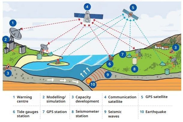
How Does the Tsunami Warning System Work?
- Step 1: Detect: A special device detects earthquakes under the sea.
- Step 2: Check: The sea-level instruments check the tsunami waves.
- Step 3: Send Warnings: The warning centre sends alerts to the government.
- Step 4: Inform People: Warning messages are sent to the people through mobile, email, etc.
Technology alone cannot protect everyone. So, from time to time, the government gives training to the people on how to understand warnings and follow safety instructions.
Marine Resources and Their Significance
When the resources come from nature, they are called natural resources, like water, forests, land, and animals. In oceans also there are many useful things; these are called marine resources, like fish, sea animals, oil, natural gas, minerals, and seawater. There are basically two types of marine resources—
- Marine Living Resources: Marine living resources are the living things found in the sea. For example, fish, crabs, sea plants, sea animals, etc.
- Marine Non-Living Resources: There are many non-living resources found in the sea, like oil, natural gas, minerals, sand, tidal energy, etc.
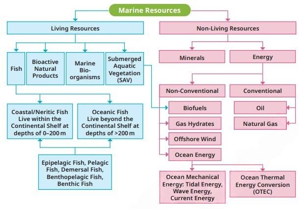
Importance of Marine Resources
Marine resources are important for many reasons.
- Food: Oceans provide fish and other seafood for people.
- Jobs: Fishing, sea trade, and tourism provide jobs to many people.
- Money: People earn money by selling seafood and providing tourism services.
- Energy: Ocean waves and tides can be used to produce electricity.
- Natural Life: Oceans provide homes for many plants and animals.
- Tourism: Beaches and coral reefs attract tourists.
Protecting Marine Resources
We have used marine resources carefully. We should not throw waste into the sea or harm any sea animals and plants. Keeping the ocean clean will help to protect marine life and keep the resources available for the feature generation.
Maritime Zones
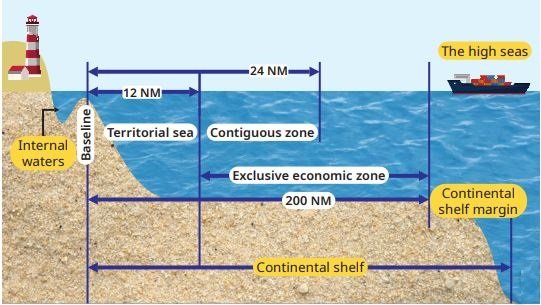
The sea is divided into different areas. These areas are called maritime zones. The international laws can tell the countries how to use their areas. There are four main maritime zones.
1. Territorial Sea
The territorial sea area is close to the country’s coast and extends up to `1 nautical mile from the coast. The country has a right to control these areas, and they can make laws about fishing, pollution and other activities. Foreign ships can pass through this area peacefully if they follow the rules.
2. Contiguous Zone
This area extends up to 24 nautical miles from the coast. In this area the country can take action against certain problems related to customs, taxes, immigration and health rules.
3. Exclusive Economic Zone (EEZ)
The exclusive economic zone extends up to 200 nautical miles from the coast. In this area, the country has a special right to use ocean resources such as fish, oil and natural gas. In this area ships of other countries can pass peacefully. In this area the country does not fully own all the water.
4. High Seas
The high seas are the parts of the ocean beyond the areas controlled for resource use by individual countries. They do not belong to any single country. All the countries are allowed to use this high seas according to the international laws. The country can use –
- Travelling by ship.
- Fishing, following international rules.
- Flying aircraft over them.
- Laying cables under the sea.
- Exploring ocean resources as allowed by law.
Important Maritime Rules and Regulations
We know about the traffic rules in the same manner ships also have to follow the rules. These rules help the ships to travel safely and avoid accidents.
1. COLREGs
The COLREGs are international rules that help the ships to avoid hitting each other. The rules tell the ship to—
- Keep watch for other ships.
- Travel at a safe speed.
- Follow the correct direction when passing other ships.
- Use lights and sound signals to warn other ships.
- Take care to avoid accidents.
- Ships also use radios to share information and stay safe.
2. MARPOL
The MARPOL is an international agreement that helps prevent pollution caused by ships. This agreement helps to control pollution from oil, waste, and other harmful materials. Its main aim is to keep the oceans clean and protect sea plants and animals.
Why Are Maritime Rules Important?
The maritime rules are important because—
- Prevent accidents: They help ships avoid hitting each other.
- Protect people: They help keep sailors and passengers safe.
- Keep oceans clean: They help reduce pollution from ships.
- Protect marine life: They help protect sea animals and plants.
- Support trade: They help ships carry goods safely between countries.
- Prevent conflicts: They help countries use ocean resources peacefully.
Disclaimer: The content that is present on our website is based on the NCERT Class 9 Social Science textbook and is provided for educational purposes only. All the content and images have been taken from Social Science Class 9 NCERT Textbook and CBSE Support material. Images and content shown above are the property of individual organizations and are used here for reference purposes only. To make it easy to understand, some of the content and images are generated by AI and cross-checked by the teachers.