
World Geography: Some Glimpses Class 8 Notes provide an interesting overview of the Earth’s maps, oceans, continents, landforms, and important geographical features. The chapter explores map projections, latitude and longitude, oceans and currents, ocean trenches, the Great Barrier Reef, seas, gulfs, bays, straits, canals, and major landforms across different continents. Students also learn about important geographical regions such as the Tibetan Plateau, Gobi Desert, European Plain, Alps, Sahara Desert, Andes Mountains, Atacama Desert, Colorado Plateau, and the Australian deserts.
World Geography Some Glimpses Class 8 Notes
The Complexity of Mapping the Earth
The earth is round but not a perfect ball. Its shape is like an oblate spheroid (a little flat at the poles). Map projection means showing the round Earth on a flat surface. For example, imagine an orange as the Earth.
- The orange is round.
- If you peel it, the peel is curved.
- Try to spread the peel completely flat without tearing or stretching it.
- You will find that it is not possible.
Every map has some mistakes; there is no map that has perfection.
- Some maps show the shape of countries correctly but the size wrong.
- Some maps show the size correctly but the shape wrong.
So, no single map is perfect. To understand the world better, we look at different maps.
Latitude and Longitude—
Professionals use latitude and longitude to show maps. This helps to identify the exact position of a place on the Earth. For example, with latitude and longitude, you can find the exact location of Delhi.
The Blue of the Blue Planet, the Oceans
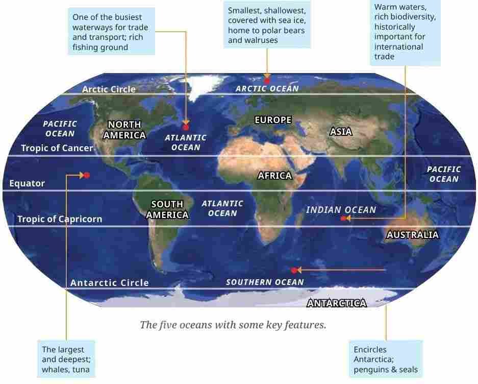
Oceans cover 71% of Earth’s surface. That’s why Earth looks blue from space and is called the Blue Planet. The oceans hold 97% of Earth’s water and support life from tiny plankton to giant blue whales.
Oceans help to control climate; they absorb heat, realize it slowly, and add moisture to the air, which helps to make clouds and rainfall.
Inside the oceans, the ocean surface is not flat; it has mountains, valleys, and plains just like land.
Ocean currents
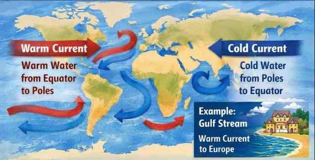
Oceans are always moving. Currents are like giant rivers inside the ocean.
- Warm currents bringing warm water from the equator toward the poles, or
- Cold currents bringing cold water from the poles toward the equator.
These currents change the climate of coastal areas. For example, the Gulf Stream brings warm water to Western Europe, making places like the UK warmer than other places at the same latitude.
Ocean trenches
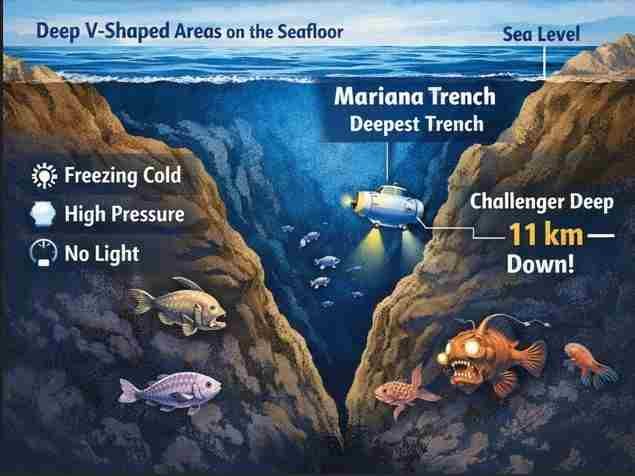
The seafloor has very deep, V-shaped areas called trenches. The Mariana Trench is the deepest of these. Near-freezing temperatures, high pressure, and complete darkness make it one of the harshest environments on Earth.
The Mariana Trench is over 11000 meters below sea level; it is deeper than Mount Everest is tall. Here life survives using chemosynthesis, which means the life makes food from chemicals, not sunlight.
The Great Barrier Reef
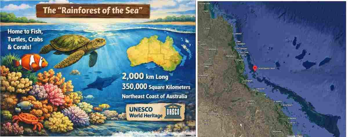
A reef is a ridge near the surface of the ocean. It is made of natural rocks or tiny sea animals called corals. Reefs are full of life. They are called the “rainforests of the sea” because they give food and shelter to many ocean animals like fish, crabs, turtles, and sponges. Nowadays these reefs are in danger because of the pollution, overfishing, and climate change. So, we have to protect them.
The Great Barrier Reef is near the northeast coast of Australia. It is about 2000 km long and covers 350000 square kilometers. It is home to hundreds of coral species and thousands of fish and sea animals. It is a UNESCO World Heritage Site because it is one of the most amazing natural places on Earth.
Smaller water bodies and waterways
It helps differentiate among the various types of formations in the sea through a system of classification and naming — seas, straits, bays, gulfs and canals — as shown in the table below.
| Type | Description | Example |
|---|---|---|
| Sea | Large, partly enclosed saltwater area connected to an ocean | Arabian Sea |
| Gulf | Large inlet of the sea deeply cutting into land | Persian Gulf |
| Bay | Smaller, broad inlet of the sea | Bay of Bengal |
| Strait | Narrow channel joining two seas or oceans | Strait of Malacca |
| Canal | Man-made channel connecting water bodies | Suez Canal |
These formations play an important role in supporting trade and transport. The Persian Gulf, for instance, has been important for trade between India and Europe for millennia. The bays provide safe havens for ports and dockyards shielding them from the strong winds of the open oceans.
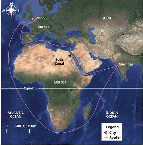
The Suez Canal is a human-made passage (opened in 1869) connecting the Red Sea with the Mediterranean, creating a waterway from the Indian Ocean to Europe.
The Continents: Variety on Land
The Earth’s land has many shapes called landforms, like mountains, plateaus, and plains. These landforms are found all over the world and affect how people live, grow food, and travel.
Roof of the world—the Tibetan Plateau
The Tibetan Plateau is the highest and largest plateau on the Earth. It lies north of the Himalayas and was formed when the two big plates, the Indo-Australian and Eurasian, collided. It is about 2,500 km long and 1,000 km wide, with an average height of 4,500 meters.
It is the source of many rivers like the Indus, Brahmaputra, and Yangtze. Scientists call this plateau the “Third Pole” because of its largest freshwater reserves outside the North and South Poles.
Gobi Desert in the ‘Land of the Eternal Blue Sky’
The Gobi Desert is a dry area where there is very little rain, less than 25 cm per year. The Gobi Desert lies in Mongolia and northern China. Mongolia is called the “Land of the Eternal Blue Sky” because it has 8 to 9 months of sunny weather. Winters are very cold up to 30°C. The people living here move their animals to find grass and water.
The Eurasian Steppes
The Eurasian Steppes are huge grassland stretching 8000 km from west to east. They act as a carbon sink, meaning they can absorb carbon dioxide and help to reduce global warming. These areas are the home of migratory birds like Siberian crane.
The Ural Mountains
The Ural Mountains are an ancient range of 2500 km long, running from the Arctic Ocean to Kazakhstan. The Ural Mountains are the natural boundary between Europe and Asia. The Ural is rich in minerals like iron, copper, gold, and coal.
The forests are the homes of animals such as brown bears, wolves, lynx, and reindeer. The land changes from cold tundra in the north to fertile farmland in the south.
Europe
The European Plain
The European Plain is one of the largest flat lands in the world. The European Plain covers many parts of the countries, and it has fertile soil, which is best for farming wheat, barley, rye, and potatoes. It also has a big reverse, which helps to make trade and transport. The plain has coal, oil, and gas, which helps the European economy. Many famous cities like Moscow, Berlin, Paris, Amsterdam, and Warsaw are built here. In historical evidence many battles were fought there, but today it is famous for agriculture and transport.
The Alps
The Alps are a crescent-shaped mountain range in southern-central Europe. These mountains are famous for skiing, hiking, and beautiful scenery. The highest peak in this mountain range is Mount Blanc. The forest grows at lower heights, and alpine flowers like edelweiss bloom in this area. Animals are also found in this area: ibex, marmots, eagles, wolves, and bears. Rivers like the Rhine and Danube start here and give water and power to Europe. The Alps are also famous for minerals like iron, copper, and salt.
Africa—Land of Deserts and Grasslands
The Sahara Desert is the largest hot desert in the world. It is very dry, with the temperature from 30°C to 46°C and little rain. People live here are the nomads who move with their animals like sheep, goats, and camels. Ancient trade routes passed through the Sahara, carrying gold and salt.
- The Savannah: The Savannah is the tropical grassland, and it has a home of elephants, lions, zebras, and giraffes. It has a dry season, which affects plant and animal movement. Human activity like farming and deforestation is harming it.
- The Nile River: The Nile River is the longest river in the world. It helps to grow Egyptian civilization. It gave water, food, electricity, and transport to millions of people.
South America – Land of Mountains and Forests
1. The Andes Mountains
The Andes Mountains are the longest mountain range in South America. They include Mount Aconcagua, the highest peak in the Western Hemisphere. The Andes feed rivers like the Amazon, the largest river by volume. The Andes Mountains are rich in minerals like copper, silver, and lithium. Many varieties of plants and animals live here.
2. The Atacama Desert
The Atacama Desert in Chile is one of the driest places on Earth. It stretches about 1000 km. In the day the temperature is 40°C, and at night 5°C.
North America – The Colorado Plateau
The Colorado Plateau is a large highland region in the southwestern United States that stretches across several states. Covering over 330,000 square km, it is renowned for its landscapes, including the Grand Canyon. Grand Canyon. Made of sedimentary rocks shaped by erosion. Rich in coal, oil, gas, copper, and uranium.
- Rocky Mountains → Stretch 4,800 km. Rich in copper, gold, and silver. Important for mining, tourism, and farming. Native Americans lived here and saw the mountains as sacred.
- Appalachian Mountains → Among the oldest ranges. Fertile valleys, forests, coal, timber, and natural gas. Important for the economy and tourism.
- Great Lakes → Five huge freshwater lakes. Important for shipping, drinking water, and wildlife. But face pollution problems.
The Australian Continent
The Great Australian Desert is a large desert like the Great Victoria Desert. The desert is the home of many animals like reptiles, wallabies, bilbies, camels, dingoes, and snakes. There are some rare species found, like the sandhill dunnart and the marsupial mole, that struggle to survive. Indigenous Spinifex people have lived here for 25,000 years. Their culture attracts tourists.
Disclaimer: The content that is present on our website is based on the NCERT Class 8 Social Science textbook and is provided for educational purposes only. All the content and images have been taken from Socail Science Class 8 NCERT Textbook. Images and content shown above are the property of individual organizations and are used here for reference purposes only. To make it easy to understand, some of the content and images are generated by AI and cross-checked by the teachers.