
← Back to Class 9 Social Science NCERT Solutions
Shaping of the Earth Surface Class 9 NCERT Solutions prepared according to the latest CBSE Class 9 Social Science syllabus. These step-by-step solutions cover every textbook question with clear explanations to help students understand important concepts such as plate tectonics, endogenic and exogenic forces, weathering, erosion, landforms, earthquakes, volcanoes, and natural disasters.
Shaping of the Earth Surface Class 9 NCERT Solutions
Q1. What are the sources of energy that are required to cause movements associated with the internal forces of the Earth?
Answer: The energy for Earth’s internal movements comes from the heat inside the Earth. The core is very hot. This heat makes the mantle move in circles, called convection currents. These currents push and pull the plates of the crust. Also, radioactive elements inside the Earth give extra heat. Because of this energy, the Earth has earthquakes, volcanoes, folding, and faulting.
Q2. Relate various physiographic divisions you have studied in the earlier grades with various endogenic forces responsible for their origin.
Answer: India’s land is divided into parts like Himalayas, Northern Plains, Peninsular Plateau, Coastal Plains, and Islands. These were made by internal forces of the Earth. The Himalayas came from plate collision and folding. The Northern Plains were shaped by rivers but their base was formed by crustal movement. The Peninsular Plateau is very old, made by volcanic activity and uplift. The Coastal Plains and Islands were formed by plate movements and volcanic eruptions.
Q3. Why and where do earthquakes occur frequently? Is it possible to predict earthquakes?
Answer: Earthquakes happen because tectonic plates move. When plates collide, slide, or pull apart, the crust shakes. Most earthquakes occur at plate boundaries. The Pacific Ocean region (Ring of Fire) has many earthquakes. In India, places like the Himalayas and Gujarat are more at risk.
Q4. “Plate movements are responsible for the distribution of earthquakes and volcanoes.” Explain.
Answer: Plate movements are the main reason for earthquakes and volcanoes. The Earth’s crust is broken into tectonic plates. These plates move slowly over the hot mantle. When plates collide, pull apart, or slide, the crust shakes and causes earthquakes. At some boundaries, magma rises through cracks, leading to volcanoes. Most earthquakes and volcanoes occur at plate boundaries, especially around the Pacific Ocean (Ring of Fire).
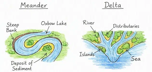
Q5. Draw and label a diagram of a meander and a delta.
Answer:
Q6. How are deforestation and erosion associated with each other? Explain.
Answer: Deforestation means cutting down trees. When trees are removed, the soil becomes loose because roots no longer hold it. Then wind and water easily carry away the soil — this is called erosion. So, deforestation increases erosion. Without trees, the land loses fertile soil, crops grow poorly, and floods can happen easily.
Q7. Develop a plan to protect the land in your local area from erosion.
Answer: To protect land from erosion, we should keep the soil covered and strong. We can plant more trees and grass because roots hold the soil. Farmers can use terracing and bunding on slopes to stop water from washing soil away. Building check dams and contour trenches helps slow down rainwater. People should also avoid cutting trees and control grazing by animals.
Q8. Which disasters do you think you might experience in your region? Discuss a mitigation plan in your classroom.
Answer: In our region, we may face landslides, floods, and droughts. Landslides can happen in hilly areas during heavy rain. Floods may occur when rivers overflow in the monsoon. Droughts can happen if rainfall is very low.
- To protect ourselves, we can make a mitigation plan in class:
- Plant more trees to stop soil erosion and landslides.
- Build check dams and bunds to control floods.
- Store rainwater in tanks and ponds to fight drought.
- Spread awareness so people know how to stay safe during disasters.
Q9. Prepare a model of landforms created by underground water.
Answer:
- Use clay or thermocol to make a base.
- Shape a cave and add stalactites (hanging from top) and stalagmites (rising from bottom).
- Make a sinkhole by pressing a round hollow in the surface.
- Show an underground river with blue color or ribbon.
- Paint and label each part clearly.
Q10. What precautionary measures will you take if you are staying in an earthquake-prone region?
Answer: If you live in an earthquake‑prone area, you must take some precautions. Build houses with strong materials and avoid very tall weak buildings. Keep emergency kits with water, food, and medicines ready. During an earthquake, do not run outside suddenly; instead, take cover under a table or stand near a strong wall. Stay away from windows, glass, and heavy objects. After the shaking stops, move to an open safe place.
Q11. Prepare a map showing landform-associated disasters that happened in the current calendar year.
Answer: In 2026, India has already faced several landform‑related disasters such as landslides in Kerala’s Wayanad, Maharashtra’s Western Ghats, and floods in Assam. These events show how plate movements, heavy rainfall, and fragile terrain combine to trigger disasters.
Major Landform‑Associated Disasters (2026)
| Disaster | Location | Cause | Impact |
|---|---|---|---|
| Wayanad Landslide | Kerala (July 2026) | Heavy monsoon rain + fragile geology | Road project buried, loss of lives, transport blocked |
| Maharashtra Landslides | Western Ghats (July 2026) | Torrential rainfall + hill cutting | Mumbai–Pune Expressway and Mumbai–Goa Highway closed |
| Assam Floods | Assam (July 2026) | Monsoon rains + river overflow | 872 villages submerged, thousands displaced |
| Himalayan Landslides | Uttarakhand, Himachal Pradesh | Continuous rainfall + tectonic activity | Roads, pilgrimage routes blocked, houses damaged |
Q13. Document a case of a disaster that hit your region in the past, highlighting its effects on various human activities.
Answer: A major disaster in Mumbai was the 2005 floods, caused by an unprecedented cloudburst of 944 mm rainfall in 24 hours. It killed over 1,000 people, displaced thousands, and exposed the city’s weak drainage and poor urban planning.
Case Study: Mumbai Floods (26 July 2005)
Background
- Date: 26 July 2005
- Rainfall: 944 mm in 24 hours — nearly half of Mumbai’s annual average.
- Cause: Extreme monsoon downpour + high tide + poor drainage capacity.
- Location: Entire Mumbai Metropolitan Region.
Effects on Human Activities
- Housing: Over 100,000 homes and shops damaged; slums worst affected.
- Transport: Railways, roads, and airports shut down; millions stranded.
- Economy: Mumbai, India’s financial capital, lost billions; stock markets and offices closed.
- Health: Over 1,000 deaths, plus waterborne diseases like leptospirosis.
- Environment: Mangrove destruction worsened flooding; Mithi River overflowed.
Lessons & Mitigation
- Drainage upgrade: BRIMSTOWAD project launched to modernize stormwater drains.
- River management: Widening and deepening of the Mithi River.
- Urban planning: Restrictions on construction debris dumping and floodplain encroachment.
- Early warning: Flood mapping and alert systems introduced.
- Community resilience: Citizens helped each other with food, shelter, and rescue.
Q14. Translate the given poster on landslide into your native language and display it in your home.
Answer:
भूस्खलन (Landslide)
सुरक्षित रहने के लिए तैयार रहें
पहले (Before):
- मिट्टी को पकड़ने वाले पेड़ लगाएँ
- रेडियो/टीवी/अखबार से चेतावनी सुनें या पढ़ें
- नालियाँ साफ रखें, पानी के रास्ते बंद न करें
- इमारत में दरारें, चट्टानों में तड़े, नदी का गंदा पानी दिखे तो सावधान रहें
- खड़ी ढलानों या नालों के पास घर न बनाएँ
भूस्खलन के दौरान (During):
- शांत रहें, घबराएँ नहीं
- अपने साथियों के साथ रहें
- पेड़ों के टूटने या पत्थरों के टकराने की आवाज़ सुनाई दे तो तुरंत दूर हटें
- भूस्खलन के रास्ते या घाटी से दूर जाएँ
- नज़दीकी तहसील/जिला मुख्यालय को सूचना दें
भूस्खलन के बाद (After):
- ढीली मिट्टी या बिजली की तारों/खंभों को न छुएँ
- भूस्खलन के रास्ते और घाटी से दूर जाएँ
- घायल और फँसे हुए लोगों को खोजें
- बिना प्राथमिक उपचार दिए घायल व्यक्ति को न हटाएँ, जब तक तत्काल खतरा न हो
- नदी, कुएँ, झरने का दूषित पानी सीधे न पिएँ
- स्मार्ट बनें, तैयार रहें!
राष्ट्रीय आपदा प्रबंधन प्राधिकरण
कॉल: 011-1078
वेबसाइट: www.ndma.gov.in
Q15. Divide the class into three groups. Each group will work on one project (water, wind, and glacier). The project should highlight the causes, impact on human life and the environment, and mitigation measures.
Answer: Water, wind, and glaciers change land. They affect farming, houses, and health. Planting trees, building dams, and careful planning can reduce damage.
Group 1: Water
- Causes: Heavy rain, rivers, floods wash away soil.
- Impact: Loss of fertile land, floods damage houses and crops.
- Mitigation: Plant trees, build bunds/check dams, keep drains clean.
Group 2: Wind
- Causes: Strong winds in dry areas blow away loose soil.
- Impact: Desertification, dust storms harm health and farming.
- Mitigation: Grow wind‑break trees, cover soil with grass, reduce over‑grazing.
Group 3: Glacier
- Causes: Moving ice cuts valleys and carries rocks.
- Impact: Creates U‑shaped valleys, floods when glaciers melt.
- Mitigation: Monitor glacier lakes, avoid construction in fragile zones, use early warning systems.
Disclaimer: The content that is present on our website is based on the NCERT Class 9 Science textbook and is provided for educational purposes only. All the content and images have been taken from Science Class 9 NCERT Textbook and CBSE Support material. Images and content shown above are the property of individual organizations and are used here for reference purposes only. To make it easy to understand, some of the content and images are generated by AI and cross-checked by the teachers.
Thank you so much. It helped a lot🫶🏻
Mindblowing website
Thanks guys for making this website
We really appriciate it❤️
Very good vebside