
← Back to Class 9 Social Science Notes
Shaping of the Earth’s Surface Class 9 Notes provide simple and well-organized study material to help students understand how natural forces continuously change the Earth’s surface. These notes explain important topics such as plate tectonics, weathering, erosion, agents of gradation, landforms created by rivers, glaciers, wind, waves, underground water, and the relationship between landforms and natural disasters.
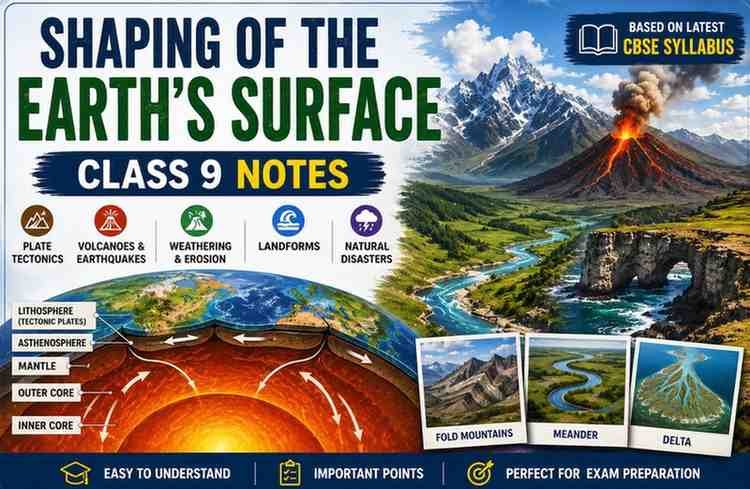
Shaping of the Earth Surface Class 9 Notes
The earth’s surface keeps changing because of its plate movement. When the plates move, they push against each other and make mountains, valleys, or oceans. Sometimes this movement causes natural events like earthquakes and volcanoes.
Why does it change?
Inside the earth there are big pieces called plates. These plates move slowly over the hot, soft layer below them. This movement is called plate tectonics.
Plate Tectonics
What is plate tectonics?
Plate Tectonics is a scientific theory proposed by W. J. Morgan that explains how the Earth’s outer layer moves.
The Earth’s outer layer is called a crust; this crust is not one big piece. It is broken into many large and small plates that fit together like a puzzle. These plates move slowly, usually 2-10 cm per year. This movement changes the Earth’s surface over millions of years.
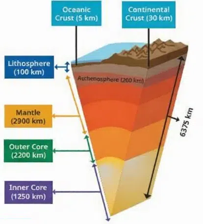
Layers of the Earth:
The Earth has three main layers—
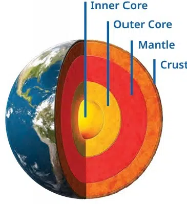
- Crust: This is the thin outer layer where we live, which is made of solid rocks.
- Mantle: This is a thick and very hot layer below the crust. It contains convection currents that move tectonic plates.
- Core: It is the deepest part and extremely hot and heavy. This core is mainly made of iron and nickel.
Lithosphere and Asthenosphere
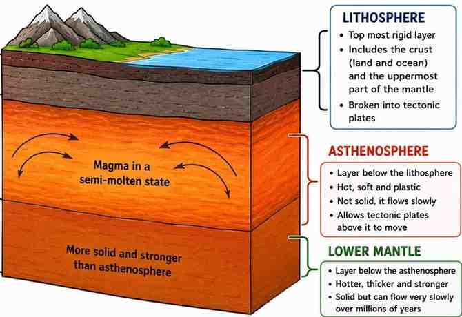
The lithosphere is the hard outer layer of the Earth. It is made up of the Earth’s crust and the uppermost part of the mantle. This layer is broken into large pieces called tectonic plates, which slowly move the layer beneath them.
The asthenosphere is the soft, semi-molten layer of the upper mantle located just below the lithosphere. It is hot and flows slowly and helps the tectonic plates of the lithosphere to move.
Types of Tectonic Plates
There are three types of tectonic plates:
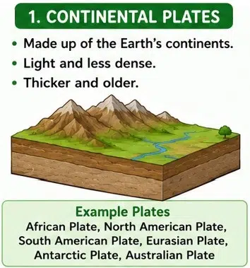
1. Continental Plate
These plates are made of continental crust, mainly granite. This is thicker, about 30-70 km, and less dense compared to the oceanic plate. For example, the Eurasian Plate, the African Plate, and the North American Plate.
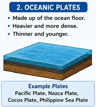
2. Oceanic Plate
The oceanic plates are mainly made of basalt. These plates are thinner, about 5 – 10 km, but denser than continental plates. For example, the Pacific plate, Nazca plate, and Cocos plate.
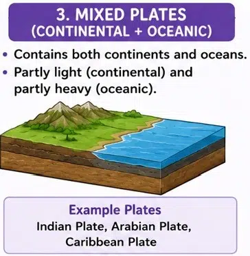
3. Mixed plates
The mixed plates contain both continental and oceanic crust. Most of the plates belong to this category, which carries continents along with parts of the ocean floor. For example, the Indian Plate, South American Plate, Australian Plate, and Antarctic Plate.
Why do tectonic plates move?
The tectonic plates move because of the heat inside the earth. This heat creates convection currents in the semi-molten asthenosphere (upper mantle), which slowly move the plate resting above it.
Types of Plate Boundaries
A plate boundary is the region where two tectonic plates meet. This movement of plates at these boundaries causes earthquakes, volcanoes and the formation of the mountains.
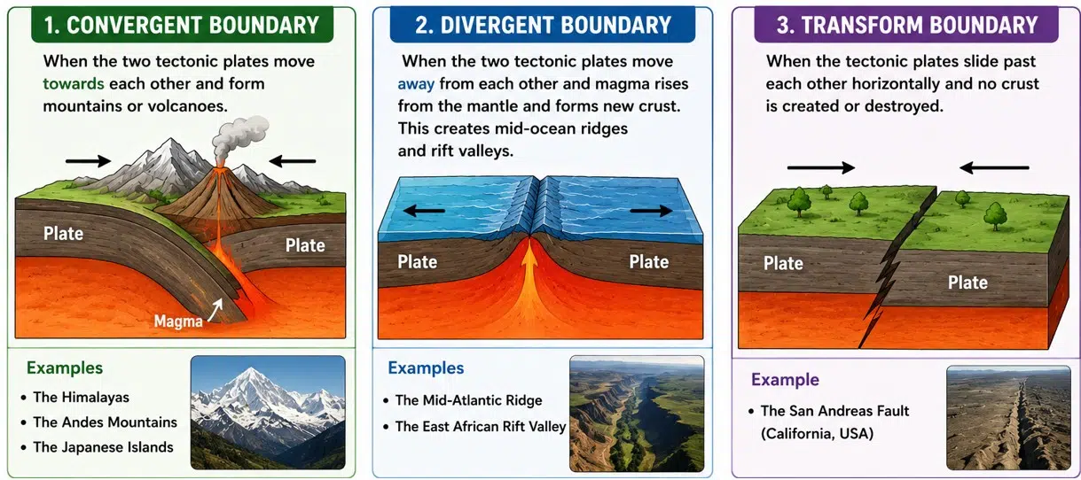
- Convergent boundary: When the two tectonic plates move towards each other and form mountains or volcanoes. For example, the Himalayas, the Andes Mountains and the Japanese Islands.
- Divergent boundary: When the two tectonic plates move away from each other and magma rises from the mantle and forms new crust. This creates mid-ocean ridges and rift valles. For example, the Mid-Atlantic Ridge and the East African Rift Valley.
- Transform boundary: When the tectonic plates slide past each other horizontally and no crust is created or destroyed. For example, the San Andreas Fault (California, USA).
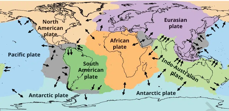
Major Tectonics Plates in world
- North American plate
- African plate Eurasian plate
- Indo-Australian plate
- Pacific plate Antarctic plate
- South American plate
- Minor Plates
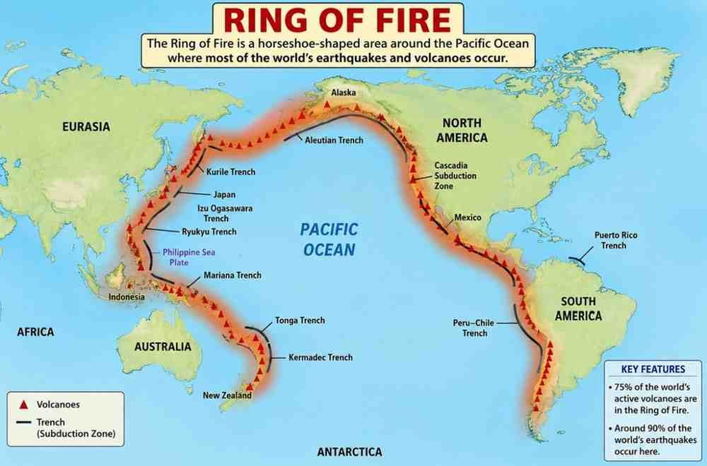
Ring of Fire
The Ring of Fire is the area around the Pacific Ocean where many earthquakes and volcanoes occur because many tectonic plates meet there.
Process of Weathering and Erosion
Weathering and erosion play an important role in the development of landforms. It is a natural process that changes the earth’s surface.
Weathering
Weathering is the process through which rocks on the Earth’s surface break down into smaller pieces due to various processes. There are three main types of weathering:
- Physical weathering: In which rocks break into smaller pieces due to temperature changes, frost or wind.
- Chemical weathering: In which minerals in rocks change because of reactions with water, air or acids, leading to new substances.
- Biological weathering: Which is caused by plants, animals or micro-organisms. For example, when plants’ roots grow into cracks of rocks and split the rock.
Erosion
Erosion is a process where the soil, rocks and other surface material are carried from one place to another place by natural agents like water, wind, ice or waves. There are several types of erosion—
- Water erosion: Caused by rivers, rain, or ocean waves;
- Wind erosion: common in dry and sandy areas;
- Glacial erosion: where moving ice scrapes and carries rocks;
- Coastal erosion: where sea waves wear away the land along the shore.
Effects of Erosion
Erosion changes the Earth’s surface by:
- Forming valleys and river channels.
- Wearing away hills and mountains.
- Changing coastlines.
- Creating new landforms over time.
Agents of Gradation
What are Agents of Gradation?
The agents of gradation are natural forces that slowly change the shapes of the earth’s surface. They do three basic things—
- Break and wear away rocks and soil.
- Carry the broken materials to another place.
- Drop (deposit) the materials in a new place.
Main Agents of Gradation
- Running Water: Running water helps to cut soil and rocks and helps to make valleys and plains. For example, Ganga plains.
- Glaciers: The ice moves and scrapes rocks and carries them away and forms U-shaped valleys. For example, Himalayas.
- Wind: Wind carries sand and dust from one place to another place; it is common in deserts and forms sand dunes. For example, the Thar Desert.
- Waves: Sea waves keep hitting the coastal area and make cliffs, beaches, and bays. For example, the Konkan coast.
- Groundwater: Groundwater flows under the earth’s surface and slowly dissolves rocks like limestone and forms caves and sinkholes. For example, Ajanta caves.
Running Water
Running water (rivers) changes the Earth’s surface in three ways: erosion, transportation, and deposition. When the river flows from the mountains to sea, it has three stages (courses).
- Upper Course (Beginning of the River): The river flows very fast and makes V‑shaped valleys, waterfalls, and rapids. For example, Jog Falls (Karnataka).
- Middle Course: The river becomes slower and make meanders, oxbow lakes and floodplains. For example, the Chambal River meanders.
- Lower Course: The river flows very slowly and drops a large amount of soil and sand and helps to make deltas, levees, and alluvial fans. For example, the Ganga-Brahmaputra delta.
1. Waterfall
A waterfall is a place where a river falls from a high cliff or a steep rock; it is usually formed in the upper course of a river.
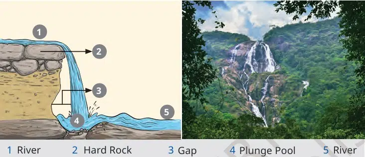
- A river flows over hard rock.
- Below the hard rock is soft rock.
- The soft rock wears away faster than the hard rock.
- This creates a steep drop.
- Water falls from this steep edge, forming a waterfall.
2. Meander
A meander is a big bend or curve in a river; it is basically found in the middle and lower courses of a river. For example, an ancient dam built across the Kaveri River is known as the Grand Anicut (Kallanai), Tamil Nadu.
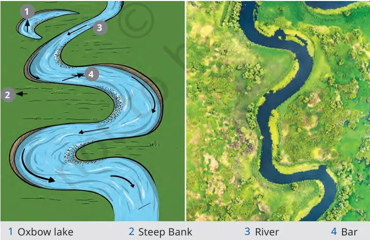
- It erodes (cuts) the outer bank of the bend.
- It deposits (drops) sand and soil on the inner bank.
- Over time, the bend becomes bigger and forms a meander.
Why are the meanders important?
The meanders are important because—
- Agriculture: Rivers deposit fertile soil near meanders.
- Settlements: Villages and towns are basically built near meanders because of the fertile land and water.
- Navigation and Irrigation: The river is used for transporting goods and watering crops.
- Tourism: It attracts tourists because it creates beautiful scenery.
3. Deltas
A delta is a fan-shaped or triangular landform formed at the mouth of a river, where the river joins a sea, ocean, or lake.
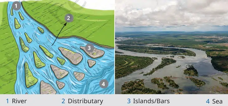
- The river reaches the sea, ocean, or lake.
- The river becomes slow.
- It drops the sediments (soil, sand, and rocks).
- Over many years, these sediments build up and form a delta.
Importance of Deltas
- Agriculture: The soil is very fertile for rice and jute.
- Fishing: Deltas have both freshwater and saltwater; because of this, many fish and other aquatic animals live here.
- Human Settlements: Many people live near deltas because of fertile land and water.
- Trade and Transport: The river in the delta helps for transporting people and goods.
Disadvantage of Deltas
- Delta regions often face floods, which can damage crops, houses, and roads.
Waves and Currents
What are waves and currents?
Waves are the up-and-down movement of seawater, and currents are the continuous flow of the seawater from one place to another place. They help to change the shape of the coastline by eroding the land and depositing sand and rocks.
Landforms Made by Waves and Currents
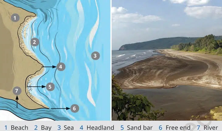
What is a beach?
A beach is a landform made up of sand, pebbles, or rocks along the shoreline of a sea, ocean, or lake, created by the deposition of sediments by waves.
Importance of Beaches
- Popular tourist places.
- Used for swimming and recreation.
- Support fishing.
- Protect the coast from strong waves and erosion.
Coastal Erosion
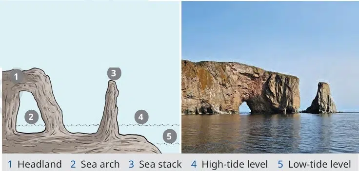
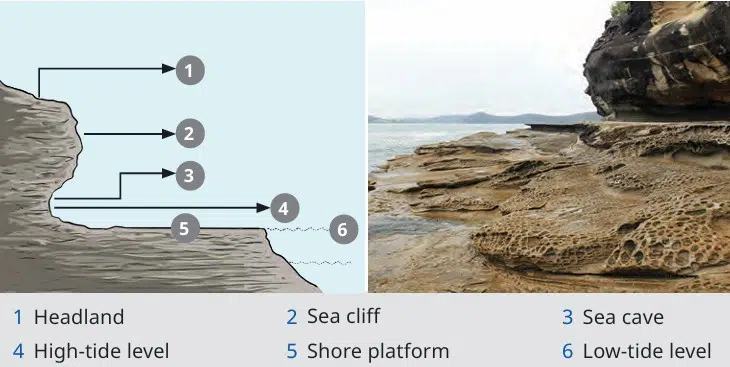
Coastal erosion occurs when waves, tides, and currents wear away the land along the coast, creating unique landforms. Coastal erosion can create many coastal landforms, like
- Sea cliff: A steep rock wall along the coast formed when waves keep hitting and wearing away the land.
- Wave-cut Platform: This is a flat rocky area left behind after a sea cliff moves backward.
- Sea Cave: When the waves slowly wear away weak rocks, then the cave is formed in the cliff.
- Sea Arch: When the waves make the cave bigger and caves meet from both sides, an arch is formed.
- Sea Stack: When the roof of the arch collapses and a tall rock pillar is left in the sea, it is called a stack.
Importance of Coastal Landforms
- Attract tourists.
- Support fishing.
- Protect some coastal areas.
- Some places need protection from coastal erosion.
Glaciers
The glaciers move slowly over the land and cut and shape the surface. Many landforms can be made by glaciers.
- U-shaped valley: It forms when a glacier moves from the narrow valley and makes it wider and deeper.
- Cirque: A cirque is found in the beginning of a glacier and formed when the glacier erodes the mountain.
- Arete: An arete is a narrow ridge between two valleys and formed when glaciers erode both sides of a mountain.
- Hanging Valley: It is a small valley that joins a large valley and is formed when the small glacier joins a bigger glacier. Waterfalls are basically found in hanging valleys.
- Fjord: A fjord is a deep and narrow sea inlet formed when seawater fills a valley made by a glacier.
Importance of Glaciers
- Glaciers are important because they:
- Provide fresh water to rivers.
- Attract tourists for trekking, skiing, and mountaineering.
- Help in fishing and transport through fjords.
- Provide fertile land for farming in some valleys.
Wind
Wind is an important agent of erosion and changes the Earth’s surface. The strong winds can carry the sand from one place to another place, loose sand and soil, and drop the sand when the wind becomes slow. Because of this, the wind changes the shape of the land, especially in deserts.
Landforms Made by Wind
Yardang: A yardang is a long and narrow ridge of rock and is formed when strong winds wear away the softer rocks and leave the harder rocks behind.
- Ventifact: A ventifact is a rock that has been polished and shaped by wind carrying sand.
- Deflation Hollow: A deflation hollow is a shallow pit or hollow formed when the wind blows away loose sand and soil from the ground.
- Desert Pavement: A desert pavement is a flat surface covered with small stones and formed when the wind removes the fine sand and leaves only the larger stones behind.
What is Dune?
The dune is a hill or ridge of sand formed by the wind; dunes are basically found in deserts and along sandy coasts. Types of dunes are
- Barchan Dune: When the wind blows in one direction and forms less sand.
- Longitudinal Dune: It is a long and narrow sand ridge and formed parallel to the wind direction.
- Star Dune: The star dune has many arms like a star. It formed where the wind blows from different directions.
- Parabolic Dune: It is a U-shaped dune. It was covered or held together by plants.
Importance of Dunes
- Dunes are useful because they:
- Stop the spread of deserts.
- Protect the land from strong winds.
- Protect coastal areas from sea waves and strong winds.
- Attract tourists for desert safaris and adventure sports.
- Provide sand that is sometimes used for construction.
Underground Water
Underground water flow below the Earth’s surface and forms special landforms called karst landforms (karst topography).
Landforms Made by Underground Water
- Cave: It is a large hollow space inside the rock or mountain. It is formed when the underground water slowly dissolves limestone rocks.
- Stalactite: It is a pointed rock hanging from the roof of a cave. It formed when the water drops leave behind minerals.
- Stalagmite: The stalagmite is a pointed rock that grows upward from the floor of a cave. It is formed by minerals left behind by dripping water.
- Sinkhole: It is a deep hole or depression in the ground. It is formed when the roof of an underground cave collapses.
- Underground river: The underground river flows below the Earth’s surface through caves.
Importance of Underground Water Landforms
These landforms are useful because they:
- Provide fresh water.
- Attract tourists.
- Are popular for adventure and cave exploration.
- Have cultural and religious importance in some places.
- Help scientists study the Earth.
Landforms and Disasters
The different landforms are connected with different natural disasters like earthquakes, volcanoes, floods, and coastal erosion. The Earth’s surface is always changing because of internal forces and external forces.
Internal Forces (inside the earth): This force comes from inside the earth and creates new landforms like
- Earthquakes
- Volcanic eruptions
- Folding (forms mountains)
- Faulting (forms valleys and rift valleys)
External Forces (Outside the Earth): These forces work on the surface of the Earth. They slowly wear away and reshape landforms like
- Weathering
- Erosion
- Deposition
Importance of Landforms
Landforms affect our daily lives because they influence:
- Climate
- Water resources
- Agriculture
- Human settlements
- Transport
- Culture and lifestyle
Why Should We Study Landforms?
Studying landforms helps us:
- Understand how the Earth changes.
- Know why natural disasters happen.
- Identify disaster-prone areas.
- Stay safe and reduce the damage caused by natural disasters.
Disclaimer: The content that is present on our website is based on the NCERT Class 9 Social Science textbook and is provided for educational purposes only. All the content and images have been taken from Social Science Class 9 NCERT Textbook and CBSE Support material. Images and content shown above are the property of individual organizations and are used here for reference purposes only. To make it easy to understand, some of the content and images are generated by AI and cross-checked by the teachers.
Thanku this notes is very useful for us thanks
In note ne mera 2 -3 hours bacha liye
I like this notes
Very nice explanation , use ful note
The notes is too good and very simple and easy…..💐
Very nice notes
Nice and easy notes
This is very important and useful
Explanation was soo good
This notes are very useful and cover many important topics very shortly and usefully with simple explanation
Honesty this notes are very understandable than NCERT
too nice, huge shout out!
Soo nice explanation