
World Geography: Some Glimpses Class 8 MCQ with Answers provides important multiple-choice questions based on the chapter World Geography: Some Glimpses. These questions cover key geographical concepts, places, physical features, and important facts from the chapter. They are useful for Class 8 students preparing for school exams, revision, and practice.
World Geography Some Glimpses Class 8 MCQ with Answers
Conceptual Recall
Q. The Earth is called an oblate spheroid because:
A. It is perfectly round
B. It bulges at the equator and is flat at the poles
C. It is shaped like a cube
D. It has mountains and valleys
Answer: B. It bulges at the equator and is flat at the poles
Q. Which of the following is the world’s largest bay?
A. Arabian Sea
B. Persian Gulf
C. Bay of Bengal
D. Strait of Malacca
Answer: C. Bay of Bengal
Q. Which of the following is a man‑made waterway?
A. Arabian Sea
B. Persian Gulf
C. Strait of Malacca
D. Suez Canal
Answer: D. Suez Canal
Q. The Eurasian Steppes are important because:
A. They are deserts with no vegetation
B. They act as a global carbon sink
C. They are the highest plateau in the world
D. They are covered with glaciers
Answer: B. They act as a global carbon sink
Q. The Ural Mountains form a natural boundary between:
A. Asia and Africa
B. Asia and Australia
C. North America and South America
D. Europe and Asia
Answer: D. Europe and Asia
Q. The Sahara Desert is the:
A. Largest cold desert in the world
B. Largest hot desert in the world
C. Smallest desert in Africa
D. Largest rainforest in the world
Answer: B. Largest hot desert in the world
Q. The Nile River is important because:
A. It is the shortest river in Africa
B. It flows only through deserts
C. It provides irrigation, transport, and hydroelectric power
D. It is a freshwater lake
Answer: C. It provides irrigation, transport, and hydroelectric power
Q. The Colorado Plateau is famous for:
A. The Grand Canyon and red rock formations
B. The Alps and Mont Blanc
C. The Sahara Desert and oases
D. The Amazon Rainforest
Answer: A. The Grand Canyon and red rock formations
Q. The Appalachian Mountains are among the:
A. Youngest mountain ranges in the world
B. Oldest mountain ranges in the world
C. Largest deserts in the world
D. Tallest plateaus in the world
Answer: B. Oldest mountain ranges in the world
Application-Based
Q. If plankton in oceans were destroyed due to pollution, what would be the most immediate effect on living beings?
A. Increase in rainfall
B. Decrease in oxygen supply
C. More ocean currents
D. Growth of deserts
Answer: B. Decrease in oxygen supply
Q. The Gulf Stream makes Western Europe warmer than other places at the same latitude because:
A. It carries cold water from the poles
B. It blocks sunlight
C. It increases rainfall in deserts
D. It carries warm water from the equator
Answer: D. It carries warm water from the equator
Q. The Bay of Bengal is important for ports and dockyards because:
A. It is the deepest trench in the world
B. It connects the Indian Ocean with Europe
C. It provides safe shelter from strong ocean winds
D. It is a freshwater body
Answer: C. It provides safe shelter from strong ocean winds
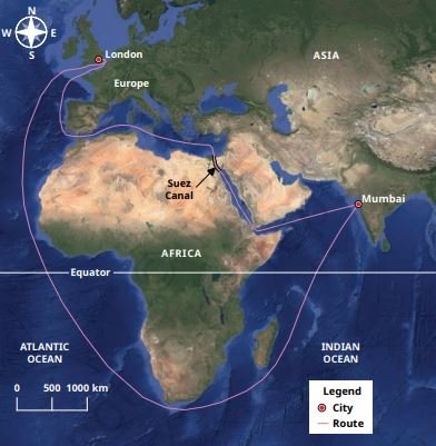
Q. The Suez Canal (Fig. 1.10) is important for India–Europe trade because:
A. It is the longest canal in the world
B. It connects the Red Sea with the Mediterranean Sea
C. It connects the Arabian Sea with the Bay of Bengal
D. It is a natural strait
Answer: B. It connects the Red Sea with the Mediterranean Sea
Q. Why are the European Plains one of the most productive agricultural regions in the world?
A. They have fertile soils and river valleys
B. They are covered with glaciers
C. They are deserts with little rainfall
D. They are volcanic mountains
Answer: A. They have fertile soils and river valleys
Q. The Alps provide water to rivers like the Rhine and Danube. What is the main benefit of this?
A. It increases desertification in Europe
B. It supplies drinking water, irrigation, and hydroelectric power
C. It blocks rainfall in Asia
D. It reduces biodiversity
Answer: B. It supplies drinking water, irrigation, and hydroelectric power
Q. Why does the Savannah ecosystem support rich wildlife like elephants, lions, and zebras?
A. It has glaciers and snow
B. It has scattered trees, grasses, and seasonal rainfall
C. It is a desert with no vegetation
D. It is a rainforest with heavy rainfall all year
Answer: B. It has scattered trees, grasses, and seasonal rainfall
Q. The Andes Mountains are called a conservation hotspot because:
A. They are deserts with no vegetation
B. They have no biodiversity
C. They are covered with glaciers all year
D. Only one-fourth of original flora and fauna remain due to human activities
Answer: D. Only one-fourth of original flora and fauna remain due to human activities
Q. Why is the Yellowstone National Park in the Rockies considered an example of ecosystem restoration?
A. Wolves were introduced to control elk, restoring balance in flora and fauna
B. Elk were removed completely from the park
C. Tourism was banned to protect wildlife
D. Mining was stopped in the Rockies
Answer: A. Wolves were introduced to control elk, restoring balance in flora and fauna
Q. The Great Lakes are vital for North America because:
A. They are deserts with no vegetation
B. They provide shipping routes, drinking water, and wildlife habitat
C. They are the highest mountains in the world
D. They are man‑made canals
Answer: B. They provide shipping routes, drinking water, and wildlife habitat
Assertion–Reason
Q. Assertion (A): The Mercator Projection is useful for navigation.
Reason (R): It preserves shape and direction but distorts size near the poles.
A. Both A and R are true, and R is the correct explanation of A
B. Both A and R are true, but R is not the correct explanation of A
C. A is true, R is false
D. A is false, R is true
Answer: A. Both A and R are true, and R is the correct explanation of A
Q. Assertion (A): Oceans are called the “Blue Planet”.
Reason (R): Oceans cover 71% of Earth’s surface and reflect blue light.
A. Both A and R are true, and R is the correct explanation of A
B. Both A and R are true, but R is not the correct explanation of A
C. A is true, R is false
D. A is false, R is true
Answer: B. Both A and R are true, but R is not the correct explanation of A
Q. Assertion (A): The Persian Gulf has been important for trade between India and Europe for millennia.
Reason (R): Gulfs are large inlets of the sea that cut deeply into land, making them useful for navigation and trade.
A. Both A and R are true, and R is the correct explanation of A
B. Both A and R are true, but R is not the correct explanation of A
C. A is true, R is false
D. A is false, R is true
Answer: A. Both A and R are true, and R is the correct explanation of A
Q. Assertion (A): The Tibetan Plateau is called the “Third Pole”.
Reason (R): It contains the largest reserves of freshwater outside the polar regions.
A. Both A and R are true, and R is the correct explanation of A
B. Both A and R are true, but R is not the correct explanation of A
C. A is true, R is false
D. A is false, R is true
Answer: A. Both A and R are true, and R is the correct explanation of A
Q. Assertion (A): The tundra in the Ural Mountains stores greenhouse gases.
Reason (R): Its frozen soil (permafrost) traps carbon dioxide and methane.
A. Both A and R are true, and R is the correct explanation of A
B. Both A and R are true, but R is not the correct explanation of A
C. A is true, R is false
D. A is false, R is true
Answer: A. Both A and R are true, and R is the correct explanation of A
Q. Assertion (A): The Amazon Rainforest is called the “Lungs of the Earth”.
Reason (R): It produces a large amount of oxygen through photosynthesis.
A. Both A and R are true, and R is the correct explanation of A
B. Both A and R are true, but R is not the correct explanation of A
C. A is true, R is false
D. A is false, R is true
Answer: A. Both A and R are true, and R is the correct explanation of A
Q. Assertion (A): The Atacama Desert is one of the driest places on Earth.
Reason (R): It has clear skies and rocky landscapes used by NASA to test rovers.
A. Both A and R are true, and R is the correct explanation of A
B. Both A and R are true, but R is not the correct explanation of A
C. A is true, R is false
D. A is false, R is true
Answer: B. Both A and R are true, but R is not the correct explanation of A
Q. Assertion (A): The Rockies are important for the US economy.
Reason (R): They provide mining, hydropower, tourism, and agriculture.
A. Both A and R are true, and R is the correct explanation of A
B. Both A and R are true, but R is not the correct explanation of A
C. A is true, R is false
D. A is false, R is true
Answer: A. Both A and R are true, and R is the correct explanation of A
Q. Assertion (A): The Great Australian Desert is home to unique animals.
Reason (R): Animals like wallabies, bilbies, and dingoes have adapted to arid conditions.
A. Both A and R are true, and R is the correct explanation of A
B. Both A and R are true, but R is not the correct explanation of A
C. A is true, R is false
D. A is false, R is true
Answer: A. Both A and R are true, and R is the correct explanation of A
Case Study Based
Q. Scientists exploring the Mariana Trench found strange snails feeding on bacteria. Since sunlight cannot reach such depths, plants cannot use photosynthesis. Instead, bacteria use chemicals in water to make food (chemosynthesis).
Question: Why is chemosynthesis important in deep ocean trenches?
A. It allows life to survive without sunlight
B. It increases rainfall on land
C. It helps plankton float
D. It reduces ocean currents
Answer: A. It allows life to survive without sunlight
Q. The Bay of Bengal is the world’s largest bay. It influences climate, supports biodiversity, and has been important in trade for centuries.
Question: Which of the following BEST explains why the Bay of Bengal is significant?
A. It is a freshwater lake
B. It is the largest bay, influencing climate and trade
C. It is a man‑made canal
D. It is a desert region
Answer: B. It is the largest bay, influencing climate and trade
Q. The steppe tortoise lives in burrows almost 2 metres deep and hibernates for 2–5 months depending on weather conditions. Two of them even travelled to the moon in 1968.
Question: What does this example show about the adaptability of steppe animals?
A. They cannot survive harsh climates
B. They adapt to seasonal changes and extreme conditions
C. They depend only on forests for survival
D. They migrate permanently to warmer regions
Answer: B. They adapt to seasonal changes and extreme conditions
Q. Dust travels all the way from the Sahara Desert to the Amazon Rainforest, carrying phosphorous needed by plants.
Question: What does this example show?
A. Deserts and rainforests are completely separate ecosystems
B. Dust storms only harm plants
C. Rainforests do not depend on nutrients
D. Natural processes connect distant ecosystems across continents
Answer: D. Natural processes connect distant ecosystems across continents
Q. The Spinifex people have lived in the Great Australian Desert for over 25,000 years. Their culture and traditions are preserved by younger generations and attract tourists.
Question: What does this example show about indigenous communities?
A. They preserve culture and adapt to harsh environments
B. They cannot survive in deserts
C. They depend only on forests for survival
D. They migrate permanently to cities
Answer: A. They preserve culture and adapt to harsh environments
Diagram/Visual-Based
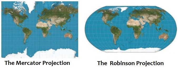
Q. Look at the world map projections (Mercator vs Robinson). In the Mercator map, Greenland looks larger than India. What does this show?
A. Maps can perfectly represent Earth
B. Mercator projection distorts size near poles
C. Robinson projection distorts direction
D. Greenland is actually bigger than India
Answer: B. Mercator projection distorts size near poles
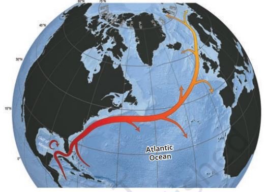
Q. The diagram of the Gulf Stream shows warm water moving northwards. What is its main effect?
A. Cooling Europe
B. Reducing rainfall in Asia
C. Increasing deserts in Africa
D. Warming Western Europe
Answer: D. Warming Western Europe
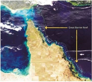
Q. The Great Barrier Reef is called the “rainforest of the sea” because:
A. It is made of trees
B. It supports one‑quarter of ocean species
C. It is located in a forest area
D. It produces rainfall
Answer: B. It supports one‑quarter of ocean species
Q. The diagram of the Suez Canal shows the shortest maritime route from India to Europe. What does this highlight?
A. Importance of natural straits
B. That canals are always longer than straits
C. That Europe is closer to India than Africa
D. Role of man‑made canals in reducing travel distance
Answer: D. Role of man‑made canals in reducing travel distance
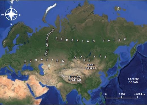
Q. The physical map of Asia shows features like the Tibetan Plateau, Gobi Desert, and Ural Mountains. Which of these is called the “Roof of the World”?
A. Gobi Desert
B. Ural Mountains
C. Tibetan Plateau
D. Eurasian Steppes
Answer: C. Tibetan Plateau
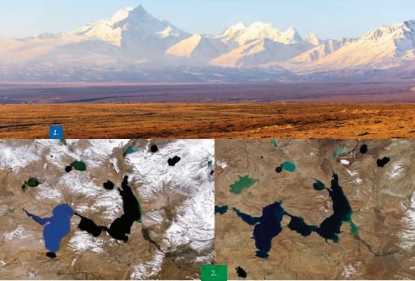
Q. Satellite images of the Tibetan Plateau (1987 vs 2021) show expansion of lakes. What is the main reason for this change?
A. Increase in rainfall due to monsoon
B. Climate change causing snow‑melt
C. Construction of canals
D. Movement of tectonic plates
Answer: B. Climate change causing snow‑melt
Q. Mongolia is called the “Land of the Eternal Blue Sky” because:
A. It has the world’s largest plateau
B. It is covered by glaciers
C. It has 8–9 months of sunny weather
D. It is surrounded by oceans
Answer: C. It has 8–9 months of sunny weather
Q. The Eurasian Steppes are shown as vast grasslands. What is their climatic feature?
A. Hot summers, cold winters, moderate seasonal rainfall
B. Heavy rainfall throughout the year
C. Always covered with snow
D. No vegetation at all
Answer: A. Hot summers, cold winters, moderate seasonal rainfall
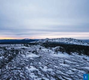
Q. The Ural Mountains are rich in minerals. Which of the following is NOT found here?
A. Iron ore
B. Copper
C. Gold
D. Diamond
Answer: D. Diamond
Q. The Alps are crescent‑shaped mountains in Europe. Which famous peak is located here?
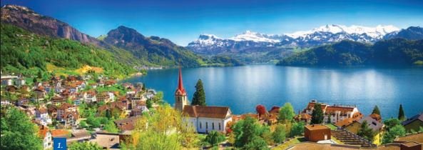
A. Mount Everest
B. Mont Blanc
C. Mount Kilimanjaro
D. Mount Aconcagua
Answer: B. Mont Blanc
Q. The map of Africa shows the Savannah between tropical rainforests and deserts. What is its climatic feature?
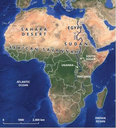
A. Heavy rainfall all year
B. Distinct wet and dry seasons
C. Always covered with snow
D. No vegetation at all
Answer: B. Distinct wet and dry seasons
Q. The Andes Mountains are shown along the west coast of South America. Which is the highest peak here?
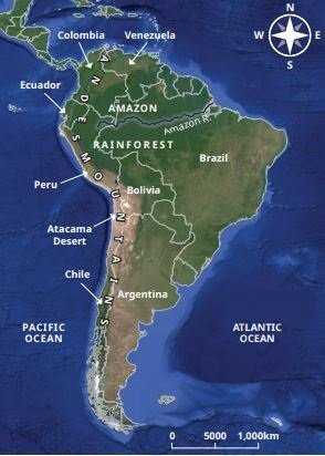
A. Mount Everest
B. Mount Kilimanjaro
C. Mount Aconcagua
D. Mont Blanc
Answer: C. Mount Aconcagua
Q. The Atacama Desert is famous for:
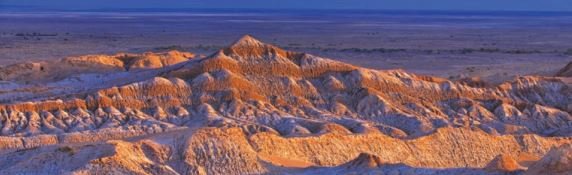
A. Heavy rainfall and dense forests
B. Clear skies for stargazing and Mars‑like landscapes
C. Being the largest rainforest in South America
D. Having the longest river in the world
Answer: B. Clear skies for stargazing and Mars‑like landscapes
Q. The Colorado Plateau is shown with the Colorado River flowing below. What does this highlight?
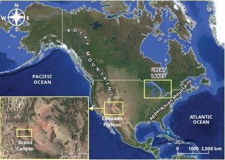
A. Plateaus are flat lands at a height above surrounding areas
B. Plateaus are deserts with no vegetation
C. Plateaus are always covered with glaciers
D. Plateaus are man‑made structures
Answer: A. Plateaus are flat lands at a height above surrounding areas
Q. The Appalachian Mountains supported indigenous communities like the Cherokee. What was their main advantage?
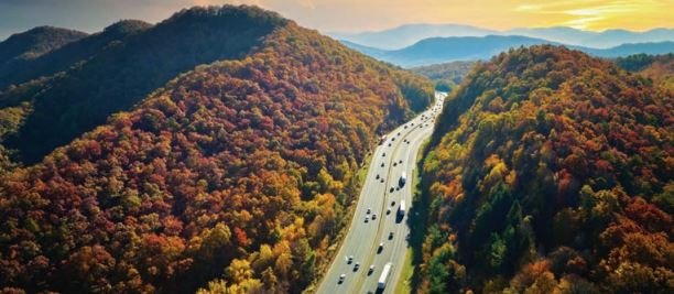
A. Fertile valleys, abundant game, and natural travel routes
B. High glaciers and snow cover
C. Rich salt flats and deserts
D. Continuous rainfall all year
Answer: A. Fertile valleys, abundant game, and natural travel routes
Q. The physical map of Australia shows large desert areas. Which desert is the largest here?
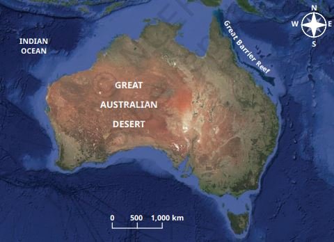
A. Sahara Desert
B. Great Victoria Desert
C. Gobi Desert
D. Atacama Desert
Answer: B. Great Victoria Desert
Disclaimer: The content that is present on our website is based on the NCERT Class 8 Social Science textbook and is provided for educational purposes only. All the content and images have been taken from Socail Science Class 8 NCERT Textbook. Images and content shown above are the property of individual organizations and are used here for reference purposes only. To make it easy to understand, some of the content and images are generated by AI and cross-checked by the teachers.