
← Back to Class 9 Social Science MCQs
Shaping of the Earth Surface Class 9 MCQ with Answers, designed according to the latest CBSE Class 9 Social Science syllabus. These multiple-choice questions cover important topics such as plate tectonics, endogenic and exogenic forces, weathering, erosion, landforms, earthquakes, volcanoes, and natural disasters.
Shaping of the Earth Surface Class 9 MCQ
Conceptual Recall MCQs
Q1. Plate tectonics was proposed by __.
a) Alfred Wegener
b) W.J. Morgan
c) Charles Lyell
d) James Hutton
Answer: b) W.J. Morgan
Q2. Lithosphere is made up of __.
a) Crust only
b) Mantle only
c) Crust + upper mantle
d) Core + mantle
Answer: c) Crust + upper mantle
Q3. The Ring of Fire is famous for __.
a) Glaciers
b) Volcanoes and earthquakes
c) Sand dunes
d) River deltas
Answer: b) Volcanoes and earthquakes
Q4. Earth’s crust thickness under continents is about __.
a) 5–7 km
b) 30–40 km
c) 100 km
d) 2900 km
Answer: b) 30–40 km
Q5. The asthenosphere is __.
a) Solid iron core
b) Semi-molten layer beneath lithosphere
c) Outer rigid crust
d) Oceanic trench
Answer: b) Semi-molten layer beneath the lithosphere
Q6. Convergent boundaries form __.
a) Fold mountains
b) Mid-ocean ridges
c) Sand dunes
d) Sinkholes
Answer: a) Fold mountains
Q7. Divergent boundaries create __.
a) Volcanoes only
b) Mid-ocean ridges and new crust
c) Earthquakes only
d) Glacial valleys
Answer: b) Mid-ocean ridges and new crust
Q8. Transform boundaries mainly cause the following __.
a) Volcanoes
b) Earthquakes
c) Deltas
d) Fjords
Answer: b) Earthquakes
Q9. The Pacific Plate is an example of __.
a) Continental plate
b) Oceanic plate
c) Mixed plate
d) None of these
Answer: b) Oceanic plate
Q10. Weathering differs from erosion because __.
a) Weathering involves movement.
b) Weathering only breaks rocks; no movement
c) Weathering is caused by glaciers.
d) Weathering is only biological.
Answer: b) Weathering only breaks rocks; no movement
Q11. Biological weathering occurs when __.
a) Rocks react with acids.
b) Plant roots split rocks.
c) Wind carries sand.
d) Ice expands cracks.
Answer: b) Plant roots split rocks.
Q12. Glacial erosion creates __.
a) U-shaped valleys
b) Sand dunes
c) Oxbow lakes
d) Sea arches
Answer: a) U-shaped valleys
Q13. Moraines are formed by __.
a) Wind deposition
b) Glacial deposition of rocks and soil
c) River erosion
d) Volcanic eruption
Answer: b) Glacial deposition of rocks and soil
Q14. Karst topography is associated with __.
a) Limestone regions
b) Desert regions
c) Coastal areas
d) Glacial valleys
Answer: a) Limestone regions
Q15. Dust storms are common in the following __.
a) Fertile plains
b) Desert and semi-arid regions
c) Coastal areas
d) Glacial valleys
Answer: b) Desert and semi-arid regions
Q16. Continental plates carry __.
a) Oceans only
b) Continents
c) Both continents and oceans
d) None of these
Answer: b) Continents
Q17. Oceanic plates carry the following __.
a) Continents
b) Ocean floors
c) Both continents and oceans
d) None of these
Answer: b) Ocean floors
Q18. Mixed plates carry __.
a) Only oceans
b) Only continents
c) Both continents and oceans
d) Only mountains
Answer: c) Both continents and oceans
Q19. Which of the following is not a major tectonic plate?
a) Pacific Plate
b) Eurasian Plate
c) African Plate
d) Arabian Plate
Answer: d) Arabian Plate (it is a minor plate).
Q20. The Indo-Australian Plate is an example of __.
a) Continental plate
b) Oceanic plate
c) Mixed plate
d) None of these
Answer: c) Mixed plate
Q21. Weathering is the process of __.
a) Breaking down rocks without movement
b) Moving soil and rocks
c) Melting glaciers
d) Depositing sediments
Answer: a) Breaking down rocks without movement
Q22. Erosion differs from weathering because _________.
a) It only breaks rocks.
b) It involves the movement of broken material.
c) It is caused only by plants.
d) It forms soil directly.
Answer: b) It involves the movement of broken material.
Q23. Physical weathering occurs due to __.
a) Plant roots splitting rocks
b) Chemical reactions with water and air
c) Heating, cooling, frost, wind, and ice expansion
d) Deposition of sediments
Answer: c) Heating, cooling, frost, wind, and ice expansion
Q24. Chemical weathering is caused by __.
a) Wind erosion
b) Reactions with water, air, or acids
c) Glacier movement
d) Sand deposition
Answer: b) Reactions with water, air, or acids
Q25. Biological weathering is caused by __.
a) Temperature changes
b) Plants, animals, or microorganisms
c) Ocean waves
d) Glacial scraping
Answer: b) Plants, animals, or microorganisms
Q26. Water erosion is mainly caused by __.
a) Rivers, rain, and ocean waves
b) Wind in deserts
c) Ice scraping rocks
d) Sea caves collapsing
Answer: a) Rivers, rain, and ocean waves
Q27. Wind erosion is common in __.
a) Fertile plains
b) Dry and sandy areas
c) Coastal regions
d) Glacial valleys
Answer: b) Dry and sandy areas
Q28. Glacial erosion occurs when __.
a) Rivers deposit sediments.
b) Moving ice scrapes and carries rocks.
c) Waves cut cliffs.
d) Wind blows sand.
Answer: b) Moving ice scrapes and carries rocks
Q29. Coastal erosion is caused by __.
a) Sea waves wearing away land
b) Wind blowing sand
c) Glaciers melting
d) Plants splitting rocks
Answer: a) Sea waves wearing away land
Q30. Erosion affects farmers most because _________.
a) It removes fertile topsoil needed for crops.
b) It destroys fishing grounds.
c) It creates caves
d) It forms glaciers.
Answer: a) It removes fertile topsoil needed for crops.
Q31. Agents of gradation are __.
a) Human activities
b) Natural forces that wear down, transport, and deposit materials
c) Only rivers and glaciers
d) Only earthquakes
Answer: b) Natural forces that wear down, transport, and deposit materials
Q32. Which agent of gradation creates caves and sinkholes?
a) Wind
b) Running water
c) Groundwater
d) Glaciers
Answer: c) Groundwater
Q33. Running water mainly forms the following __.
a) Valleys and plains
b) Sand dunes
c) Fjords
d) Sea arches
Answer: a) Valleys and plains
Q34. Glaciers carve __.
a) U-shaped valleys
b) Sand bars
c) Oxbow lakes
d) Sinkholes
Answer: a) U-shaped valleys
Q35. Wind shapes __.
a) Deserts by eroding and depositing sand
b) River valleys
c) Coastal cliffs
d) Glacial moraines
Answer: a) Deserts by eroding and depositing sand
Q36. Upper course rivers usually form the following __.
a) Deltas
b) V-shaped valleys, waterfalls, rapids
c) Beaches
d) Sand dunes
Answer: b) V-shaped valleys, waterfalls, rapids
Q37. Meanders are formed due to __.
a) Wind erosion
b) Lateral erosion and deposition of sediments
c) Glacial scraping
d) Volcanic activity
Answer: b) Lateral erosion and deposition of sediments
Q38. Deltas are highly fertile because ________.
a) They have volcanic soil.
b) They have rich alluvial deposits.
c) They are formed by glaciers.
d) They are formed by wind erosion.
Answer: b) They have rich alluvial deposits.
Q39. Beaches are formed by __.
a) Deposition of sediments by waves
b) Glacial erosion
c) Wind deposition
d) River flooding
Answer: a) Deposition of sediments by waves
Q40. Glacial erosion creates __.
a) Sand dunes
b) U-shaped valleys, cirques, fjords
c) Oxbow lakes
d) Beaches
Answer: b) U-shaped valleys, cirques, fjords
Q41. Cirques are __.
a) Sharp ridges between valleys
b) Bowl-shaped depressions at the head of a glacier
c) Deep inlets formed by sea flooding valleys
d) Fertile plains
Answer: b) Bowl-shaped depressions at the head of a glacier
Q42. Aretes are __.
a) Valleys formed by rivers
b) Sharp ridges between valleys
c) Deposits of glacial soil
d) Sand bars along coasts
Answer: b) Sharp ridges between valleys
Q43. Moraines are formed by __.
a) Wind deposition
b) Glacial deposition of rocks, soil, and debris
c) River flooding
d) Volcanic eruptions
Answer: b) Glacial deposition of rocks, soil, and debris
Q44. Yardangs are _.
a) Rocks polished by sandblasting
b) Streamlined rock ridges carved by wind
c) Bowl-shaped depressions
d) Fertile plains
Answer: b) Streamlined rock ridges carved by wind
Q45. Ventifacts are __.
a) Rocks polished and shaped by wind-driven sand
b) Valleys carved by glaciers
c) Deposits of river soil
d) Limestone caves
Answer: a) Rocks polished and shaped by wind-driven sand
Q46. Deflation hollows are formed when __.
a) Glaciers scrape valleys.
b) Loose material is removed by wind.
c) Rivers deposit sediments.
d) Volcanoes erupt.
Answer: b) Loose material is removed by wind.
Q47. Barchan dunes are __.
a) Crescent-shaped dunes formed in areas with limited sand and a single wind direction
b) Long ridges parallel to wind
c) Multi-armed dunes formed by winds from different directions
d) U-shaped dunes stabilized by vegetation
Answer: a) Crescent-shaped dunes formed in areas with limited sand and a single wind direction.
Q48. Karst topography is formed by __.
a) Wind erosion
b) Groundwater dissolving limestone
c) Glacial scraping
d) River flooding
Answer: b) Groundwater dissolving limestone
Application-Based MCQs
Q49. When erosion removes fertile topsoil, which occupation suffers most?
a) Fishing
b) Farming
c) Mining
d) Tourism
Answer: b) Farming
Q50. If two continental plates collide, what landform is created?
a) Rift valley
b) Fold mountains
c) Ocean trench
d) Delta
Answer: b) Fold mountains
Q51. A delta is highly fertile because
a) It has volcanic soil.
b) It has rich alluvial deposits.
c) It is formed by glaciers.
d) It is formed by wind erosion.
Answer: b) It has rich alluvial deposits.
Q52. If sea waves continuously erode a coastline, which landform is most likely to form?
a) Delta
b) Cliff
c) Glacier
d) Sand dune
Answer: b) Cliff
Q53. Farmers in limestone regions often face sinkholes. This is due to __.
a) Wind erosion
b) Groundwater dissolving rocks
c) Glacial scraping
d) River flooding
Answer: b) Groundwater dissolving rocks
Q54. In deserts, wind deposition creates __.
a) Beaches
b) Sand dunes
c) Fjords
d) Valleys
Answer: b) Sand dunes
Q55. Farmers near meanders benefit because _______.
a) Soil is infertile.
b) Fertile soil is deposited along banks.
c) Glaciers scrape valleys.
d) Sand dunes protect crops.
Answer: b) Fertile soil is deposited along banks.
Q56. Waterfalls are useful for humans because _______.
a) They only attract tourists.
b) They can generate hydroelectric power.
c) They form caves.
d) They create deserts.
Answer: b) They can generate hydroelectric power.
Q57. Coastal erosion can affect human settlements by __.
a) Creating fertile plains
b) Wearing away land, houses, and roads
c) Depositing sand dunes
d) Forming glaciers
Answer: b) Wearing away land, houses, and roads
Q58. Fjords are useful for humans because __.
a) They provide fertile soil.
b) They are used as harbors and fishing grounds.
c) They form deserts.
d) They create caves.
Answer: b) They are used as harbors and fishing grounds.
Q59. Fertile glacial soil in valleys supports the following __.
a) Tourism only
b) Agriculture
c) Mining
d) Desertification
Answer: b) Agriculture
Q60. Moraines can benefit humans by __.
a) Forming natural dams and lakes for irrigation and hydroelectric power
b) Creating sand dunes
c) Producing volcanic soil
d) Supporting coral reefs
Answer: a) Forming natural dams and lakes for irrigation and hydroelectric power
Q61. Sand dunes protect human settlements by the following __.
a) Blocking rivers
b) Acting as barriers against desertification and strong winds
c) Creating fertile plains
d) Forming caves
Answer: b) Acting as barriers against desertification and strong winds
Q62. Stalactites and stalagmites attract geologists and tourists because _______.
a) They are volcanic features.
b) They are unique cave formations created by underground water.
c) They are formed by glaciers.
d) They are sand dunes.
Answer: b) They are unique cave formations created by underground water.
Q63. Landslides often occur due to the following __.
a) Continuous rainfall, earthquakes, and deforestation
b) Wind erosion only
c) Glacial melting only
d) Volcanic eruptions only
Answer: a) Continuous rainfall, earthquakes, and deforestation
Assertion–Reason MCQs
Q64. Assertion (A): Most earthquakes occur along plate boundaries.
Reason (R): Plate boundaries are zones of intense crustal movement.
a) Both A and R are true, and R explains A.
b) Both A and R are true, but R does not explain A.
c) A is true, R is false.
d) A is false, R is true.
Answer: a) Both A and R are true, and R explains A.
Q65. Assertion (A): Weathering involves the breaking down of rocks without movement.
Reason (R): Erosion involves movement of broken material.
a) Both A and R are true, and R explains A.
b) Both A and R are true, but R does not explain A.
c) A is true, R is false.
d) A is false, R is true.
Answer: a) Both A and R are true, and R explains A.
Q66. Assertion (A): Most earthquakes occur along plate boundaries.
Reason (R): Plate boundaries are zones of crustal movement.
a) Both A and R are true, and R explains A.
b) Both A and R are true, but R does not explain A.
c) A is true, R is false
d) A is false, R is true
Answer: a) Both A and R are true, and R explains A.
Q67. Assertion (A): Glaciers act as powerful agents of gradation.
Reason (R): They scrape and carry huge amounts of material, carving valleys.
a) Both A and R are true, and R explains A.
b) Both A and R are true, but R does not explain A.
c) A is true, R is false
d) A is false, R is true
Answer: a) Both A and R are true, and R explains A.
Q68. Assertion (A): Groundwater can create caves.
Reason (R): It dissolves limestone through chemical weathering.
a) Both A and R are true, and R explains A.
b) Both A and R are true, but R does not explain A.
c) A is true, R is false
d) A is false, R is true
Answer: a) Both A and R are true, and R explains A.
Q69. Assertion (A): Deltas support dense human settlements.
Reason (R): They provide fertile soil and navigable routes for trade.
a) Both A and R are true, and R explains A.
b) Both A and R are true, but R does not explain A.
c) A is true, R is false
d) A is false, R is true
Answer: a) Both A and R are true, and R explains A.
Q70. Assertion (A): Beaches act as natural barriers.
Reason (R): They protect settlements from strong waves and coastal erosion.
a) Both A and R are true, and R explains A.
b) Both A and R are true, but R does not explain A.
c) A is true, R is false
d) A is false, R is true
Answer: a) Both A and R are true, and R explains A.
Q71. Assertion (A): Glaciers are important sources of fresh water.
Reason (R): They feed rivers that sustain human populations downstream.
a) Both A and R are true, and R explains A.
b) Both A and R are true, but R does not explain A.
c) A is true, R is false
d) A is false, R is true
Answer: a) Both A and R are true, and R explains A.
Q72. Assertion (A): Terminal moraines mark the furthest advance of glaciers.
Reason (R): They are formed at the end of glaciers when deposition occurs.
a) Both A and R are true, and R explains A.
b) Both A and R are true, but R does not explain A.
c) A is true, R is false
d) A is false, R is true
Answer: a) Both A and R are true, and R explains A.
Q73. Assertion (A): Avalanches occur when snow becomes unstable on steep slopes.
Reason (R): Heavy snowfall, sudden temperature rise, or vibrations can disturb the snowpack.
a) Both A and R are true, and R explains A.
b) Both A and R are true, but R does not explain A.
c) A is true, R is false
d) A is false, R is true
Answer: a) Both A and R are true, and R explains A.
Q74. Assertion (A): Dust storms are common in desert regions.
Reason (R): Loose dry soil and sparse vegetation make it easy for wind to lift particles.
a) Both A and R are true, and R explains A.
b) Both A and R are true, but R does not explain A.
c) A is true, R is false
d) A is false, R is true
Answer: a) Both A and R are true, and R explains A.
Case-Based MCQ
Q75. Case Study: In 2021, Chamoli (Uttarakhand) faced a sudden flood due to the collapse of a glacial lake dam.
This disaster is an example of the following:
a) Landslide
b) Avalanche
c) Glacial Lake Outburst Flood (GLOF)
d) Dust storm
Answer: c) Glacial Lake Outburst Flood (GLOF)
Q76. Case Study: A village near a limestone region suddenly experiences land subsidence. A large depression forms, swallowing part of a road and nearby farmland. Scientists explain that underground water dissolved limestone, creating a cavity that collapsed.
Question: This disaster is an example of:
a) Landslide
b) Sinkhole formation
c) Avalanche
d) Dust storm
Answer: b) Sinkhole formation
Q77. Case Study: The Sundarbans delta is famous for its unique biodiversity and mangrove forests. It supports agriculture, fishing, and dense settlements but is also prone to flooding and cyclones.
Question: The Sundarbans delta is an example of _______.
a) A glacial valley
b) A fertile delta formed by river deposition
c) A desert dune system
d) A volcanic plateau
Answer: b) A fertile delta formed by river deposition
Q78. Case Study: A valley in the Himalayas shows fertile soil, a U-shaped valley, and a natural lake formed by glacial deposits. Farmers grow crops there, while tourists visit for trekking and skiing.
Question: Which glacial landform is most responsible for the lake formation?
a) Cirque
b) Moraine
c) Fjord
d) Arete
Answer: b) Moraine
Q79. Case Study: In Ladakh, a glacial lake suddenly burst due to rising temperatures and heavy rainfall. Downstream villages were flooded, damaging houses, roads, and fields.
Question: This disaster is an example of:
a) Landslide
b) Avalanche
c) Glacial Lake Outburst Flood (GLOF)
d) Dust storm
Answer: c) Glacial Lake Outburst Flood (GLOF)
Q80. Case Study: In February 2021, the Chamoli district of Uttarakhand faced a devastating flood. Many hydel projects, bridges, and villages were destroyed. Scientists later found that melting glaciers and sudden collapse of ice/moraine dams caused the disaster.
Question: The Chamoli flood is an example of
a) Landslide
b) Avalanche
c) Glacial Lake Outburst Flood (GLOF)
d) Dust storm
Answer: c) Glacial Lake Outburst Flood (GLOF)
Diagram-Based MCQs
Q81. Refer to Figure (waterfall diagram). Waterfalls form because:

a) Hard rock resists erosion; soft rock erodes faster.
b) Wind deposits sand.
c) Glaciers carve valleys.
d) Waves cut cliffs.
Answer: a) Hard rock resists erosion; soft rock erodes faster.
Q82. Refer to Figure (Sea arch and stack). A sea stack is formed when:
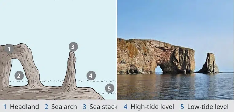
a) A cave collapses
b) An arch collapses, leaving a pillar
c) A cliff retreats
d) A dune stabilizes
Answer: b) An arch collapses, leaving a pillar.
Q83. Refer to Figure (U-shaped valley). U-shaped valleys are formed by:
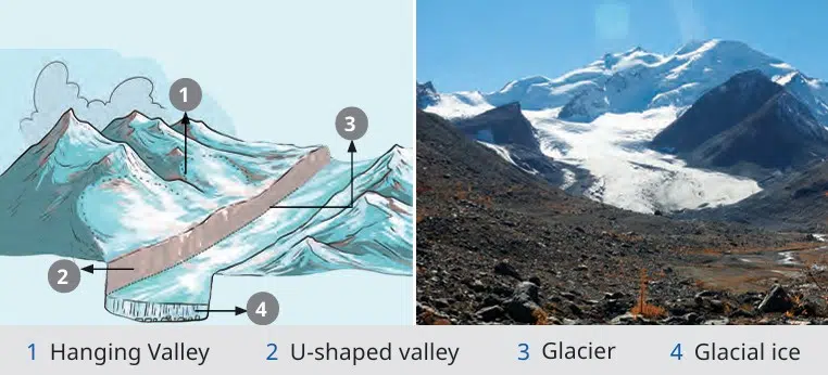
a) Rivers
b) Glaciers
c) Wind
d) Waves
Answer: b) Glaciers
Q84. Refer to Figure (waterfall diagram). Waterfalls form because:
a) Hard rock resists erosion; soft rock erodes faster.
b) Wind deposits sand.
c) Glaciers carve valleys.
d) Waves cut cliffs.
Answer: a) Hard rock resists erosion; soft rock erodes faster.
Q85. Refer to Figure (Glacial landforms). Which feature is a sharp ridge between valleys?
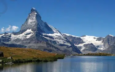
a) Cirque
b) Arete
c) Fjord
d) Moraine
Answer: b) Arete
Q86. Refer to Figure (Oasis diagram). An oasis forms because _______.
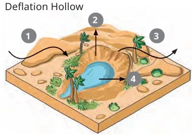
a) Wind deposits sand
b) The water table is exposed in desert depressions.
c) Glaciers melt.
d) Sea waves retreat
Answer: b) The water table is exposed in desert depressions.
Q87. Refer to Figure (waterfall diagram). Waterfalls form because:
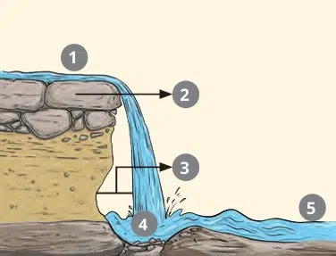
a) Hard rock resists erosion; soft rock erodes faster.
b) Wind deposits sand.
c) Glaciers carve valleys.
d) Waves cut cliffs.
Answer: a) Hard rock resists erosion; soft rock erodes faster.
Q88. Refer to Figure (Meander diagram). An oxbow lake is formed when:
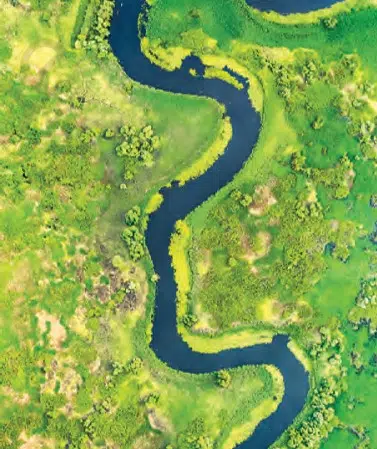
a) A glacier melts
b) A river loop is cut off from the main channel.
c) Waves erode cliffs.
d) Wind blows sand.
Answer: b) A river loop is cut off from the main channel.
Q89. Refer to Figure (Delta diagram). Deltas form at:
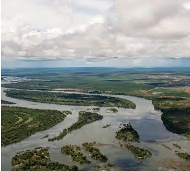
a) River source
b) River mouth where it meets sea/ocean
c) Middle course of river
d) Desert regions
Answer: b) River mouth where it meets sea/ocean
Q90. Refer to Figure (Glacial landforms). Which feature is a bowl-shaped depression?
a) Arete
b) Cirque
c) Fjord
d) Moraine
Answer: b) Cirque
Q92. Refer to Figure (Moraines). Medial moraines are formed when:
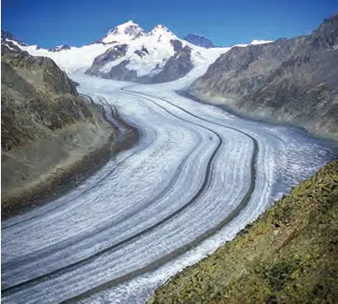
a) Two glaciers meet and their lateral moraines join in the middle.
b) Glaciers retreat, leaving soil
c) Wind deposits sand.
d) Rivers cut valleys
Answer: a) Two glaciers meet, and their lateral moraines join in the middle.
Q93. Refer to Figure (Yardang diagram). Yardangs are formed by:
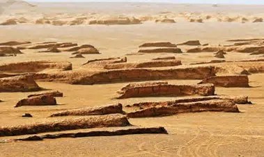
a) Wind carving soft rock, leaving ridges of hard rock
b) Glaciers scraping valleys
c) Rivers depositing soil
d) Volcanoes erupting
Answer: a) Wind carving soft rock, leaving ridges of hard rock
Q94. Refer to Figure (cave diagram). Stalactites form when:
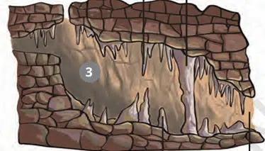
a) Water drips from cave ceilings, depositing minerals.
b) Sand is blown by wind.
c) Glaciers melt.
d) Rivers’ floodplains
Answer: a) Water drips from cave ceilings, depositing minerals.
Q95. Refer to Figure (landslide diagram). Landslides occur when:
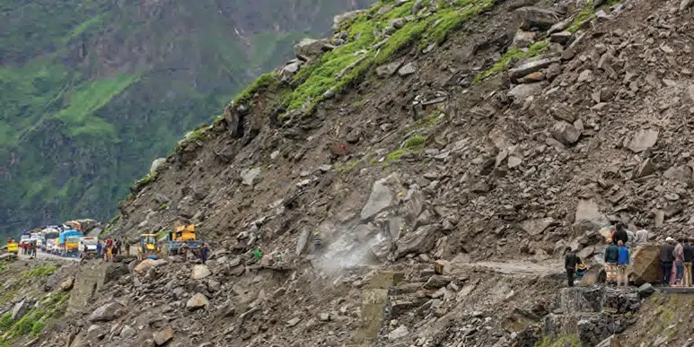
a) Slopes become unstable due to rainfall, earthquakes, or human activity.
b) Wind blows sand.
c) Glaciers carve valleys.
d) Waves erode cliffs.
Answer: a) Slopes become unstable due to rainfall, earthquakes, or human activity.
Disclaimer: The content that is present on our website is based on the NCERT Class 9 Social Science textbook and is provided for educational purposes only. All the content and images have been taken from Social Science Class 9 NCERT Textbook and CBSE Support material. Images and content shown above are the property of individual organizations and are used here for reference purposes only. To make it easy to understand, some of the content and images are generated by AI and cross-checked by the teachers.
Excellent MCQS, NOTES AND DIAGRAMS
THANK YOU SO MUCH 🙏🏻