
← Back to Class 9 Social Science MCQs
Practice important multiple-choice questions (MCQs) from the Class 9 Social Science chapter Oceans and Life. These questions cover ocean relief, ocean movements, tides, ocean currents, marine resources, maritime zones, and ocean conservation. Test your knowledge and revise the important concepts to prepare for your examinations.
Oceans and Life Class 9 MCQ
Conceptual Recall
Q. Which ocean floor feature is an immense underwater mountain range formed by volcanic activity?
a) Ocean Trench
b) Mid-Ocean Ridge
c) Abyssal Plain
d) Continental Shelf
Answer: b) Mid-Ocean Ridge
Q. The deepest parts of the ocean are known as:
a) Abyssal Plains
b) Continental Shelves
c) Ocean Trenches
d) Rift Valleys
Answer: c) Ocean Trenches
Q. When the surface of the ocean rises and falls alternately, it is called a:
a) Current
b) Tide
c) Wave
d) Whirlpool
Answer: c) Wave
Q. Which of the following is the horizontal distance between two consecutive wave crests or troughs?
a) Wave Height
b) Wavelength
c) Wave Period
d) Wave Frequency
Answer: b) Wavelength
Q. Ocean currents are best described as:
a) Temporary movements of waves near the shore
b) Continuous streams of water flowing in definite directions
c) Rising and falling of ocean water twice a day
d) Sudden movements caused only by earthquakes
Answer: b) Continuous streams of water flowing in definite directions
Q. Currents that flow from colder regions towards warmer regions are called:
a) Warm currents
b) Seasonal currents
c) Cold currents
d) Tidal currents
Answer: c) Cold currents
Q. What is the main purpose of the GEMINI device developed for fishermen?
a) To measure ocean depth only
b) To provide weather forecasts, warnings, and fishing advisories
c) To increase the speed of fishing boats
d) To generate tidal energy
Answer: b) To provide weather forecasts, warnings, and fishing advisories
Q. Cyclones are primarily caused by:
a) Atmospheric disturbances over warm ocean waters
b) Earthquakes beneath the ocean floor
c) Volcanic eruptions on land
d) Strong tidal currents
Answer: a) Atmospheric disturbances over warm ocean waters
Q. Resources obtained from oceans that have intrinsic or economic value are known as:
a) Terrestrial resources
b) Forest resources
c) Marine resources
d) Renewable resources
Answer: c) Marine resources
Q. Which maritime zone extends up to 200 nautical miles from a country’s baseline?
a) Territorial Sea
b) Contiguous Zone
c) Internal Waters
d) Exclusive Economic Zone (EEZ)
Answer: d) Exclusive Economic Zone (EEZ)
Q. The international rules that help prevent collisions between ships at sea are known as:
a) MARPOL
b) UNCLOS
c) COLREGs
d) EEZ Rules
Answer: c) COLREGs
Q. Which international convention focuses on preventing pollution from ships?
a) COLREGs
b) MARPOL
c) NCRMP
d) SSEWS
Answer: b) MARPOL
Application-Based
Q. A fishing company wants to operate in a shallow marine area rich in marine life and petroleum resources. Which area would be most suitable?
a) Continental Shelf
b) Ocean Trench
c) Mid-Ocean Ridge
d) Rift Valley
Answer: a) Continental Shelf
Q. During a tsunami warning, people living near the coast are safely evacuated. Which technology helps provide such early warnings?
a) Compass and maps
b) Weather balloons only
c) Seismic sensors and satellites
d) Fishing vessels
Answer: c) Seismic sensors and satellites
Q. A country promotes sustainable fishing and offshore renewable energy while protecting marine ecosystems. This is an example of:
a) Deep-sea mining
b) Blue Economy
c) Maritime trade
d) Continental drift
Answer: b) Blue Economy
Q. A coastal area is experiencing continuous erosion, leading to the formation of sea caves and arches. Which oceanic agent is mainly responsible for this change?
a) Ocean currents
b) Groundwater
c) Tides
d) Waves
Answer: d) Waves
Q. A Very Large Crude Carrier (VLCC) wants to pass through a shallow sea channel safely. It is most likely to wait for:
a) Low tide
b) Neap tide
c) High tide
d) Storm waves
Answer: c) High tide
Q. Fishermen often prefer fishing during high tide because:
a) Fish move closer to the shore in search of food and shelter
b) The sea becomes completely calm
c) Ocean currents stop flowing
d) Water temperature becomes very low
Answer: a) Fish move closer to the shore in search of food and shelter
Q. Why does the Norwegian coast remain relatively ice-free despite being located at a high latitude?
a) It receives water from the Gulf Stream
b) It experiences frequent tsunamis
c) It is affected only by cold currents
d) It has very low rainfall
Answer: a) It receives water from the Gulf Stream
Q. A coastal area experiences increased sea ice and icebergs due to the influence of a cold ocean current. Which current is most likely responsible?
a) Gulf Stream
b) Labrador Current
c) Indian Monsoon Current
d) Equatorial Current
Answer: b) Labrador Current
Q. Fishermen often prefer areas where warm and cold currents meet because these regions:
a) Have very calm water
b) Are free from storms
c) Have shallow ocean floors
d) Are rich in nutrients and fish
Answer: d) Are rich in nutrients and fish
Q. A fisherman receives a warning about high waves and strong winds on his mobile phone through a GEMINI device. What should he do first?
a) Move farther into the sea
b) Ignore the warning and continue fishing
c) Take necessary precautions and move to a safer location
d) Switch off the device
Answer: c) Take necessary precautions and move to a safer location
Q. A coastal district regularly faces cyclones. Which government initiative helps by building cyclone shelters and strengthening warning systems?
a) Project Tiger
b) National Cyclone Risk Mitigation Project (NCRMP)
c) Smart Cities Mission
d) Jal Jeevan Mission
Answer: b) National Cyclone Risk Mitigation Project (NCRMP)
Q. Why are public awareness and training programmes important in disaster management?
a) They help people respond correctly to disaster warnings
b) They reduce ocean currents
c) They prevent earthquakes from occurring
d) They increase fish production
Answer: a) They help people respond correctly to disaster warnings
Q. A ship is travelling through a crowded sea route with many vessels nearby. Which rule is most important for avoiding accidents?
a) Maintaining a proper lookout and following COLREGs
b) Increasing the ship’s speed continuously
c) Switching off communication equipment
d) Ignoring navigation lights
Answer: a) Maintaining a proper lookout and following COLREGs
Q. A cargo vessel disposes of oily waste directly into the sea. Which international agreement is being violated?
a) Blue Economy Framework
b) COLREGs
c) MARPOL
d) Innocent Passage Rule
Answer: c) MARPOL
Q. Two ships from different countries are navigating in the same ocean region. Why is it important that both follow common maritime rules?
a) To increase territorial claims
b) To ensure safe and orderly navigation
c) To restrict international trade
d) To reduce the size of shipping fleets
Answer: b) To ensure safe and orderly navigation
Q. A coastal country wants to explore and extract offshore oil and natural gas deposits up to 200 nautical miles from its coast. In which maritime zone can it exercise these special rights?
a) High Seas
b) Exclusive Economic Zone (EEZ)
c) International Waters
d) Continental Shelf Margin only
Answer: b) Exclusive Economic Zone (EEZ)
Q. A company develops tidal and wave energy projects while ensuring the protection of marine ecosystems. This approach best represents:
a) Overfishing
b) Deep-sea mining
c) Blue Economy
d) Illegal fishing
Answer: c) Blue Economy
Q. A foreign ship passes through the territorial waters of a country without stopping and without carrying out any fishing activity. This is an example of:
a) Illegal navigation
b) Innocent Passage
c) Resource exploration
d) Coastal tourism
Answer: b) Innocent Passage
Assertion–Reason
Q. Assertion (A): Tides are important for navigation and tidal energy generation.
Reason (R): Tides are caused by the gravitational pull of celestial bodies.
a) Both A and R are true, and R is the correct explanation of A
b) Both A and R are true, but R is not the correct explanation of A
c) A is true, but R is false
d) A is false, but R is true
Answer: a) Both A and R are true, and R is the correct explanation of A
Q. Assertion (A): Abyssal plains are among the flattest regions on Earth.
Reason (R): They are located on high mountain ranges beneath the ocean.
a) Both A and R are true
b) A is false, but R is true
c) Both A and R are false
d) A is true, but R is false
Answer: d) A is true, but R is false
Q. Assertion (A): Spring tides have unusually high high tides and unusually low low tides.
Reason (R): During spring tides, the Sun, Earth, and Moon are aligned in a straight line.
a) Both A and R are true, and R is the correct explanation of A
b) Both A and R are true, but R is not the correct explanation of A
c) A is true, but R is false
d) A is false, but R is true
Answer: a) Both A and R are true, and R is the correct explanation of A
Q. Assertion (A): Neap tides show a smaller difference between high tide and low tide.
Reason (R): During neap tides, the gravitational pull of the Sun and Moon acts in different directions.
a) A is true, but R is false
b) Both A and R are false
c) Both A and R are true, and R is the correct explanation of A
d) A is false, but R is true
Answer: c) Both A and R are true, and R is the correct explanation of A
Q. Assertion (A): Ocean currents influence the climate of nearby coastal regions.
Reason (R): Ocean currents transport water with different temperatures from one region to another.
a) Both A and R are true, and R is the correct explanation of A
b) Both A and R are true, but R is not the correct explanation of A
c) A is true, but R is false
d) A is false, but R is true
Answer: a) Both A and R are true, and R is the correct explanation of A
Q. Assertion (A): Early Warning Systems help reduce the loss of life during cyclones and tsunamis.
Reason (R): They provide timely warnings that allow people to evacuate to safer places.
a) A is true, but R is false
b) Both A and R are false
c) Both A and R are true, and R is the correct explanation of A
d) A is false, but R is true
Answer: c) Both A and R are true, and R is the correct explanation of A
Q. Assertion (A): The 2004 Indian Ocean Tsunami led many countries to strengthen their disaster management systems.
Reason (R): The tsunami caused widespread loss of life and damage in countries bordering the Indian Ocean.
a) Both A and R are true, and R is the correct explanation of A
b) Both A and R are true, but R is not the correct explanation of A
c) A is true, but R is false
d) A is false, but R is true
Answer: a) Both A and R are true, and R is the correct explanation of A
Q. Assertion (A): Tsunami detection buoys play an important role in tsunami warning systems.
Reason (R): They help detect, measure, and monitor tsunami waves in real time.
a) A is false, but R is true
b) Both A and R are false
c) Both A and R are true, and R is the correct explanation of A
d) A is true, but R is false
Answer: c) Both A and R are true, and R is the correct explanation of A
Q. Assertion (A): Maritime laws help protect marine environments.
Reason (R): International agreements regulate pollution and ship operations.
a) Both A and R are true, and R is the correct explanation of A
b) Both A and R are true, but R is not the correct explanation of A
c) A is true, but R is false
d) A is false, but R is true
Answer: a) Both A and R are true, and R is the correct explanation of A
Q. Assertion (A): Without maritime regulations, oceans could become more dangerous for navigation.
Reason (R): Maritime rules establish common standards for ships of all countries.
a) A is false, but R is true
b) Both A and R are false
c) Both A and R are true, and R is the correct explanation of A
d) A is true, but R is false
Answer: c) Both A and R are true, and R is the correct explanation of A
Q. Assertion (A): Marine resources are important for food security and livelihoods.
Reason (R): Fishing and aquaculture provide employment and fish are a major source of protein.
a) Both A and R are true, and R is the correct explanation of A
b) Both A and R are true, but R is not the correct explanation of A
c) A is true, but R is false
d) A is false, but R is true
Answer: a) Both A and R are true, and R is the correct explanation of A
Q. Assertion (A): The high seas are considered part of the global commons.
Reason (R): No single country owns or controls the high seas.
a) A is true, but R is false
b) Both A and R are false
c) Both A and R are true, and R is the correct explanation of A
d) A is false, but R is true
Answer: c) Both A and R are true, and R is the correct explanation of A
Case Study-Based
Case Study: A coastal city frequently faces the threat of cyclones and tsunamis. The government has installed advanced monitoring systems that continuously observe seismic activity and ocean conditions. Whenever a possible hazard is detected, warning messages are quickly sent to coastal communities, helping people move to safer locations.
Q. Which system plays the most important role in detecting tsunami threats?
a) Fishing boats
b) Lighthouses
c) Seismic sensors and satellites
d) Cargo ships
Answer: c) Seismic sensors and satellites
Q. The main purpose of early warning systems is to:
a) Increase ocean trade
b) Support tourism
c) Study marine animals
d) Reduce loss of life and property
Answer: d) Reduce loss of life and property
Case Study: A cargo ship approaches a port that has a large tidal range. Before entering the harbour, the captain checks the tidal chart and decides to wait for a few hours. The port authority explains that the water level will soon rise, allowing the ship to enter safely without touching the seabed.
Q. The captain is waiting for:
a) Low tide
b) High tide
c) Tsunami
d) Ocean current
Answer: b) High tide
Q. High tides are important for navigation because they:
a) Reduce the depth of water near the shore
b) Stop the movement of waves
c) Increase the speed of ships automatically
d) Raise the water level, making harbour entry easier
Answer: d) Raise the water level, making harbour entry easier
Case Study: A coastal village receives a warning from the disaster management authority that a severe cyclone may strike the area within the next 24 hours. Residents are advised to move to cyclone shelters immediately. The warning was issued using advanced monitoring and forecasting systems.
Q. The main purpose of issuing such warnings is to:
a) Increase fishing activities
b) Promote tourism
c) Reduce loss of life and property
d) Stop ocean currents
Answer: c) Reduce loss of life and property
Q. Which Indian project focuses on strengthening warning systems and improving cyclone preparedness?
a) Blue Economy Mission
b) National Cyclone Risk Mitigation Project (NCRMP)
c) Sagarmala Project
d) Project Tiger
Answer: b) National Cyclone Risk Mitigation Project (NCRMP)
Case Study: An undersea earthquake occurs in the Indian Ocean. Seismic stations detect the earthquake immediately. Ocean Bottom Pressure Recorders confirm the movement of tsunami waves, and warning messages are quickly sent through satellites, SMS, and other communication networks. Coastal residents are evacuated to safer locations.
Q. Which component of the warning system confirms the passage of tsunami waves?
a) GPS satellite
b) Ocean Bottom Pressure Recorder (OBPR)
c) Coastal display board
d) Cyclone shelter
Answer: b) Ocean Bottom Pressure Recorder (OBPR)
Q. What is the main objective of issuing tsunami alerts quickly?
a) To improve fishing activities
b) To increase tourism
c) To reduce communication costs
d) To save lives and reduce disaster impact
Answer: d) To save lives and reduce disaster impact
Case Study: A coastal state plans to increase economic growth by promoting fishing, offshore renewable energy, and marine tourism. At the same time, the government introduces measures to reduce marine pollution and conserve marine ecosystems to ensure long-term sustainability.
Q. Which concept is reflected in the government’s approach?
a) Maritime Expansion
b) Ocean Mining
c) Blue Economy
d) Territorial Control
Answer: c) Blue Economy
Q. According to the concept of Blue Economy, economic growth should be achieved while:
a) Ignoring marine conservation
b) Expanding fishing without limits
c) Restricting all marine activities
d) Preserving the health of marine ecosystems
Answer: d) Preserving the health of marine ecosystems
Case Study: A large commercial ship is travelling through an international shipping route. The crew continuously monitors nearby vessels, follows navigation lights and sound signals, maintains a safe speed, and communicates with other ships using radio systems. The vessel also follows regulations for waste disposal to avoid polluting the sea.
Q. The navigation practices followed by the ship are mainly guided by:
a) EEZ Regulations
b) COLREGs
c) Blue Economy Principles
d) Fishing Laws
Answer: b) COLREGs
Q. The rules related to preventing pollution from ships are covered under:
a) MARPOL
b) UNCLOS
c) NCRMP
d) GEMINI
Answer: a) MARPOL
Diagram/Visual-Based
Q. Refer to Figure. Which labelled feature represents the steep edge marking the true boundary of a continent?
a) Abyssal Plain
b) Continental Shelf
c) Continental Slope
d) Seamount
Answer: c) Continental Slope
Q. Refer to Figure. Which labelled feature represents a volcanic mountain rising from the ocean floor that may eventually form an island?
a) Seamount
b) Trench
c) Abyssal Plain
d) Continental Rise
Answer: a) Seamount
Q. Refer to Figure. What is the term used for the highest point of a wave?
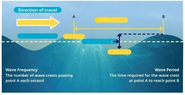
a) Trough
b) Wavelength
c) Crest
d) Wave Period
Answer: c) Crest
Q. Refer to Figure. Which coastal landform is formed when the roof of a sea arch collapses due to gravity?
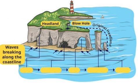
a) Sea Cave
b) Blow Hole
c) Headland
d) Sea Stack
Answer: d) Sea Stack
Q. Refer to Figure. The currents shown in red on the map generally represent:
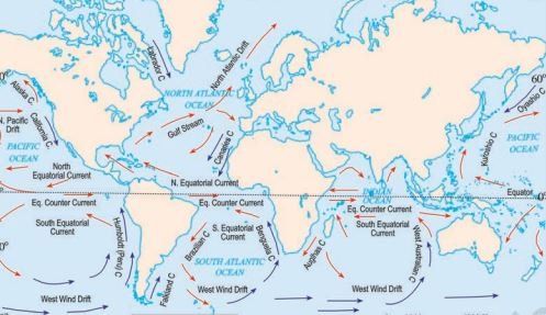
a) Cold currents
b) Deep ocean currents
c) Warm currents
d) Tidal currents
Answer: c) Warm currents
Q. Refer to Figure. Which ocean current shown on the map flows from the Gulf of Mexico towards Europe and helps keep nearby waters warmer?
a) Labrador Current
b) Gulf Stream
c) Peru Current
d) Benguela Current
Answer: b) Gulf Stream
Q. Refer to Figure. Which stage of the tsunami early warning system involves sending alerts to government agencies and the public?
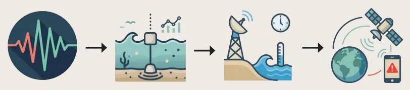
a) Detection
b) Confirmation
c) Tracking
d) Warning Dissemination
Answer: d) Warning Dissemination
Q. Refer to Figure. Which instrument shown in the tsunami early warning system detects earthquake-generated seismic waves?
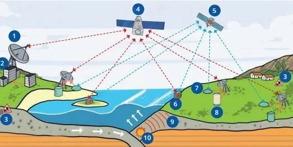
a) Tide Gauge Station
b) Warning Centre
c) Seismometer Station
d) Communication Satellite
Answer: c) Seismometer Station
Q. Which marine resource category includes oil, natural gas, minerals, and ocean energy?
a) Living Resources
b) Non-Living Resources
c) Fish Resources
d) Biodiversity Resources
Answer: b) Non-Living Resources
Q. Refer to Figure. Which maritime zone extends from the baseline up to 24 nautical miles and allows a country limited control over customs and illegal immigration?
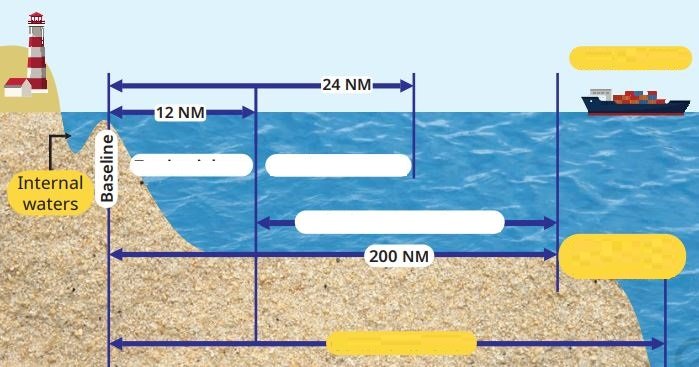
a) Territorial Sea
b) Exclusive Economic Zone
c) Contiguous Zone
d) High Seas
Answer: c) Contiguous Zone
Q. Refer to the diagram showing international maritime communication signals in the chapter. What is the main purpose of these signals?
a) To increase cargo capacity
b) To identify fishing zones
c) To prevent accidents and share important information
d) To measure ocean depth
Answer: c) To prevent accidents and share important information
Q. Refer to the diagram showing navigation lights and vessel signals in the chapter. These signals help sailors to:
a) Detect minerals on the seabed
b) Predict earthquakes
c) Generate tidal energy
d) Identify vessels and avoid collisions
Answer: d) Identify vessels and avoid collisions
Disclaimer: The content that is present on our website is based on the NCERT Class 9 Social Science textbook and is provided for educational purposes only. All the content and images have been taken from Social Science Class 9 NCERT Textbook and CBSE Support material. Images and content shown above are the property of individual organizations and are used here for reference purposes only. To make it easy to understand, some of the content and images are generated by AI and cross-checked by the teachers.