
Practice India’s Urban Landscape Class 8 MCQs with answers to revise important concepts from the chapter. These questions cover key ideas related to urban development, towns, cities, settlements, and the changing urban landscape of India. They are useful for quick revision, exam preparation, and self-assessment.
India’s Urban Landscape Class 8 MCQs
Conceptual Recall MCQ
Q. Which local body governs villages in India?
a) Municipality
b) Gram Panchayat
c) District Court
d) State Assembly
Answer: b) Gram Panchayat
Q. Which of the following factors helped cities grow historically?
a) Location near rivers
b) Crossroads of trade routes
c) Access to raw materials
d) All of the above
Answer: d) All of the above
Q. Urbanisation means:
a) Population shift from urban to rural areas
b) Population shift from rural to urban areas
c) Population remaining constant in villages
d) Population only growing in forests
Answer: b) Population shift from rural to urban areas
Q. Which festival of Kolkata was inscribed on UNESCO’s Intangible Cultural Heritage list in 2021?
a) Diwali
b) Durga Puja
c) Holi
d) Eid
Answer: b) Durga Puja
Q. Who was the chief architect and planner of Jaipur in 1727?
a) Maharaja Sawai Jai Singh II
b) Vidyadhar Bhattacharya
c) Sir Dorabji Tata
d) Raffles
Answer: b) Vidyadhar Bhattacharya
Q. Which of the following is a “blue zone” city where people live longer, healthier lives?
a) Singapore
b) Mumbai
c) Delhi
d) Bengaluru
Answer: a) Singapore
Application‑Based MCQ
Q. A city has many offices, shops, and transport systems. Which of the following BEST explains why it is called “urban”?
a) It has fewer people and more farms
b) It has concentration of population, jobs, and institutions
c) It has only agriculture‑based occupations
d) It has no elected local bodies
Answer: b) It has concentration of population, jobs, and institutions
Q. A city is located near a river and at a trade route crossing. Which of the following is MOST likely to happen?
a) The city will remain small with few jobs
b) The city will grow as a centre of trade and manufacturing
c) The city will only depend on farming
d) The city will have no political importance
Answer: b) The city will grow as a centre of trade and manufacturing
Q. Sakchi village grew into Jamshedpur because:
a) It was near fertile farmland
b) It was close to iron ore deposits and industries developed there
c) It was a pilgrimage centre
d) It was a capital city
Answer: b) It was close to iron ore deposits and industries developed there
Q. A city has many libraries, museums, and stadiums. Which of the following BEST explains their importance?
a) They only serve tourists
b) They enrich socio‑cultural life and create hubs for knowledge and interaction
c) They reduce population density
d) They stop migration
Answer: b) They enrich socio‑cultural life and create hubs for knowledge and interaction
Q. Singapore updates its Master Plan every 5 years. Why is this important?
a) To keep the plan fixed permanently
b) To reflect changing needs of infrastructure and population
c) To reduce population density
d) To stop migration
Answer: b) To reflect changing needs of infrastructure and population
Q. Ahmedabad’s Sabarmati Riverfront project blends ecology with public utility. Which of the following is the MOST direct benefit of such planning?
a) More factories built along the river
b) Cleaner environment with promenades, parks, and public spaces
c) Decline in tourism
d) Reduction in literacy rate
Answer: b) Cleaner environment with promenades, parks, and public spaces
Assertion–Reason MCQ
Q. Assertion (A): Population density is measured as people per square kilometre.
Reason (R): It shows how crowded or spacious a place is.
a) Both A and R are true, and R is the correct explanation of A.
b) Both A and R are true, but R is not the correct explanation of A.
c) A is true, but R is false.
d) A is false, but R is true.
Answer: a) Both A and R are true, and R is the correct explanation of A.
Q. Assertion (A): By 2050, 68% of the world’s population will live in cities.
Reason (R): Cities provide better opportunities for jobs, education, and services.
a) Both A and R are true, and R is the correct explanation of A.
b) Both A and R are true, but R is not the correct explanation of A.
c) A is true, but R is false.
d) A is false, but R is true.
Answer: a) Both A and R are true, and R is the correct explanation of A.
Q. Assertion (A): Mumbai became India’s financial capital.
Reason (R): The Bombay Stock Exchange (BSE) was set up in 1875, boosting trade and commerce.
a) Both A and R are true, and R is the correct explanation of A.
b) Both A and R are true, but R is not the correct explanation of A.
c) A is true, but R is false.
d) A is false, but R is true.
Answer: a) Both A and R are true, and R is the correct explanation of A.
Q. Assertion (A): NCR often records AQI levels above 400.
Reason (R): High AQI indicates severe air pollution, which is harmful to health.
a) Both A and R are true, and R is the correct explanation of A.
b) Both A and R are true, but R is not the correct explanation of A.
c) A is true, but R is false.
d) A is false, but R is true.
Answer: a) Both A and R are true, and R is the correct explanation of A.
Q. Assertion (A): Jaipur is called the “Pink City.”
Reason (R): Buildings along major streets were built using pink sandstone, giving the city a uniform look.
a) Both A and R are true, and R is the correct explanation of A.
b) Both A and R are true, but R is not the correct explanation of A.
c) A is true, but R is false.
d) A is false, but R is true.
Answer: a) Both A and R are true, and R is the correct explanation of A.
Q. Assertion (A): Singapore promotes vertical and rooftop gardens in high‑rise buildings.
Reason (R): They reduce heat, support biodiversity, and make the city aesthetically pleasing.
a) Both A and R are true, and R is the correct explanation of A.
b) Both A and R are true, but R is not the correct explanation of A.
c) A is true, but R is false.
d) A is false, but R is true.
Answer: a) Both A and R are true, and R is the correct explanation of A.
Case Study MCQ
Q. A village in Haryana has large green and brown open areas, while Gurugram city nearby shows a dense network of grey buildings.
Which of the following is the MOST accurate inference?
a) Gurugram has lower population density than the village
b) The village has higher population density than Gurugram
c) Gurugram has higher population density due to more built‑up areas
d) Both have equal population density
Answer: c) Gurugram has higher population density due to more built‑up areas
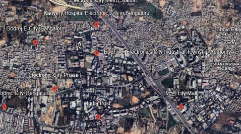
Q. Satellite images of Bengaluru (2012 vs 2025) show more buildings and fewer open spaces in 2025.
Which of the following is the MOST likely cause of this change?
a) Decline in population
b) Rapid urbanisation and migration
c) Increase in forest cover
d) Fall in trade activities
Answer: b) Rapid urbanisation and migration
Q. Bengaluru became known as the “Silicon Valley of India” due to the presence of software firms, start‑ups, and higher education institutions.
Which of the following BEST explains why Bengaluru became an IT hub?
a) It had fertile soil for farming
b) It had clusters of specialised industries and universities encouraging innovation
c) It was a port city near the sea
d) It was India’s capital city
Answer: b) It had clusters of specialised industries and universities encouraging innovation
Q. Bengaluru once had nearly 1,000 lakes, but rapid urbanisation reduced them to about 200, many polluted by sewage. Communities revived some lakes through desilting, planting native species, and restocking fish.
Which of the following is the MOST likely benefit of such revival efforts?
a) Increase in traffic congestion
b) Better water availability and ecological balance
c) Decline in literacy rate
d) More slums in the city
Answer: b) Better water availability and ecological balance
Q. Singapore transformed from an overcrowded port in the 1960s into a modern city‑state with strong infrastructure. It promotes mixed‑use spaces and sustainable high‑rise buildings with rooftop gardens.
Which of the following is the MOST likely benefit of such planning?
a) More reliance on cars
b) Reduced heat, better biodiversity, and high quality of life
c) Decline in education levels
d) Increase in pollution
Answer: b) Reduced heat, better biodiversity, and high quality of life
Q. Gangtok’s Mahatma Gandhi Road is a pedestrian‑only shopping hub known for its cleanliness and vibrant atmosphere.
Which of the following is the MOST likely impact of such planning?
a) More traffic congestion in the city centre
b) Safer and more enjoyable public spaces for residents and tourists
c) Decline in local businesses
d) Increase in pollution levels
Answer: b) Safer and more enjoyable public spaces for residents and tourists
Diagram/Visual‑Based MCQ
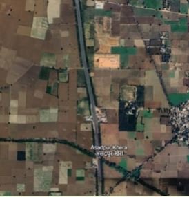
Q. In Figure (satellite images), the village shows more green land and fewer buildings. What does this indicate?
a) High population density
b) Low population density
c) Equal density as city
d) No population at all
Answer: b) Low population density
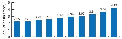
Q. In Figure (World’s Most Populous Cities in 2025), which Indian cities are among the top ten?
a) Mumbai and Chennai
b) Kolkata and New Delhi
c) Bengaluru and Hyderabad
d) Pune and Jaipur
Answer: b) Kolkata and New Delhi
Q. In Figure (Process of Urbanisation), the shift from farming to industries and services represents:
a) Rural stagnation
b) Early urbanisation
c) Decline in population
d) Migration to forests
Answer: b) Early urbanisation
Q. Challenges Faced by Cities, which of the following is NOT shown as a challenge?
a) Traffic jams
b) Poor air quality
c) Flooding during monsoons
d) Increase in literacy rate
Answer: d) Increase in literacy rate
Q. In Figure(Map of Jaipur, 1914), the grid pattern dividing the city into rectangular blocks is based on:
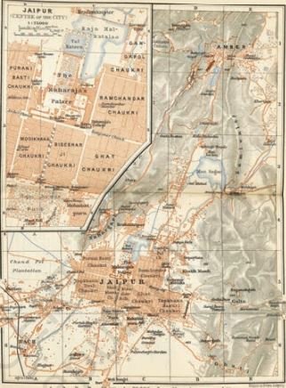
a) Random design
b) Vāstu shāstra and śhilpa shāstra principles
c) European planning only
d) Railway expansion
Answer: b) Vāstu shāstra and śhilpa shāstra principles
Q. In Figure (Buildings with vertical gardens and Flower Dome), what do these features represent?
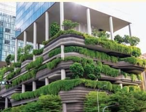
a) Traditional architecture only
b) Use of sustainable technologies for urban living
c) Decline in biodiversity
d) Expansion of slums
Answer: b) Use of sustainable technologies for urban living
Disclaimer: The content that is present on our website is based on the NCERT Class 8 Social Science textbook and is provided for educational purposes only. All the content and images have been taken from Socail Science Class 8 NCERT Textbook. Images and content shown above are the property of individual organizations and are used here for reference purposes only. To make it easy to understand, some of the content and images are generated by AI and cross-checked by the teachers.